Locality
Arctic Slope of Alaska locality USGS 11606, north of Maybe Creek. This locality is a bluff approximately 10 m high on the east side of an unnamed tributary of the Price River. The predominant lithologies are bentonitic clays overlying a silty sandstone capped by coal beds up to 2 m thick, which are in turn overlain by a white-gray medium-grained sandstone. Irregularly dispersed throughout the clay are nodules and sheets of ferruginous limestone (sideritic) which, although light gray when fresh, weather to a rusty brown. With the exception of some poorly preserved plant matter in the upper sandstones, and impressions of platanoid leaves in the power sandtsones, the plant material is confined to these fine-grained iron-rich nodules and is preserved as impressions totally lacking cuticle. There is little evidence of post-mortem decay but many leaves are penetrated by vertical fossil rootlets. Platanoid leaves are most common in siltier/sandier facies. The uppermost coal surface supports several in situ tree bases each of which is approximately 20 cm in diameter.
Latitude: 69.528329 °N
Longitude: -153.887128 °W
Description
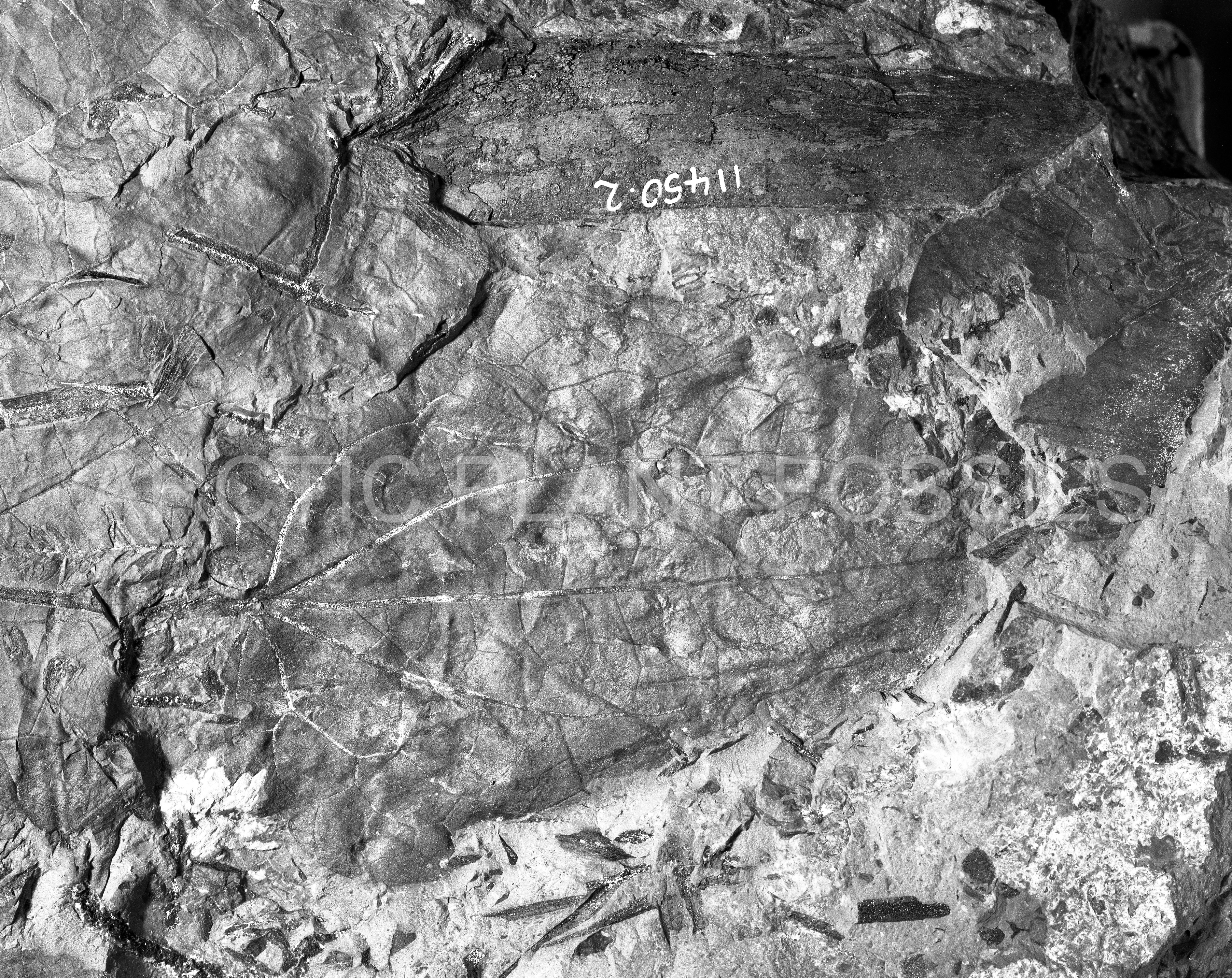
Leaf: simple; symmetrical; wide ovate; apex obtuse; base cordate; margin crenate, sinuses angular, teeth apices rounded with a glandular termination of the medial vein, the medial vein subtended by brochidodromous higher order veins; petiole inflated; venation suprabasal perfect acrodromous, primary midvein moderate, straight; pectinal veins of primary order but slightly weaker than midvein, uniformly curved but with a tendency to break into a series of shallow curved arches, pectinal abmedial veins diverging from the pectinals at wide acute, variable angles, somewhat fine, abruptly curved forming a series of angular festooned brochidodromous loops, joining the superadjacent abmedials at approximately right angles and enclosed by third and fourth order arches; tertiary veins tending to be percurrent convex, but often repeatedly forked and approaching a random reticulation, tertiaries at the base of leaf concentrically arranged with respect to the top of petiole; fourth order veins in the area of lamina enclosed by the pectinal veins forming an orthogonal reticulum and often indistinguishable from the tertiaries.
Remarks
Of the fossil forms from sediments of Cretaceous age a specimen assigned to Trochodendroides (Cercidiphyllum) arctica (Heer) Berry by Bell (1957, p. 45; Plate 35, Fig. 2) from the Newcastle Formation appears to have most characters in common with specimen USGS 11606.2. Although Bell does not give details of the tooth venation, the gross venation of that part of Bell's specimen that is present is almost identical to the equivalent part of specimen USGS 11606.2 in that secondaries arising from the midvein are not well developed and the area between the pectinal veins has a generally poorly organized venation system. This is in contrast to other specimens attributed to Trochodendroides arctica (Heer) Bell by Bell in an earlier publication (Bell, 1949) which have well-developed looping secondaries arising from the midvein, especially near the apex. The apices of these specimens are also angular rather than rounded. Some of Bell's specimens, however, do not fit this description (Plate 46, Fig. 2) and Bell admits that the range of forms he ascribes to this species is great and more than one species may be represented.
There are marked features of specimen USGS 11606.2 that set it apart from all the specimens so far discussed. The degree of acrodromy seems particularly well developed and pectinal exmedials enclose areas that are more isodiametric, rather than elongate, in shape. The comparative antiquity of this form compared to the uppermost Cretaceous and Tertiary occurrences of similar forms may be reflected in the rather poorly organized venation between the pectinal veins, and local irregularities throughout the venation.