Kukpowruk River
| Introduction | Geology | Kukpowruk Unassigned Fossils | Fossil Images |
|---|
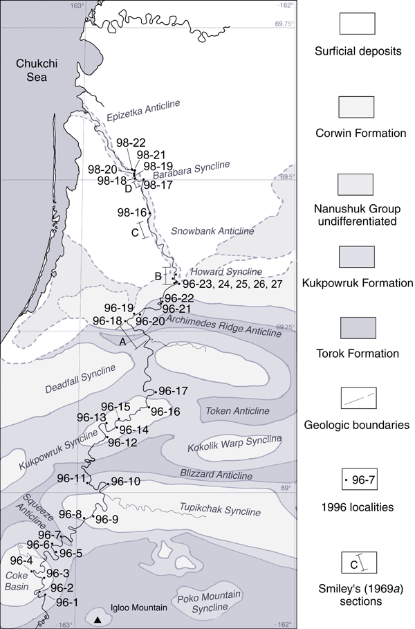
The map on the right shows the localities along the Kukpowruk River sampled both by Smiley (reported in Smiley 1969a), Spicer and Herman (1996) and by Bob and Andrew Spicer in 1998. Click on the locality numbers to see further details of the sites and the fossil floras. |
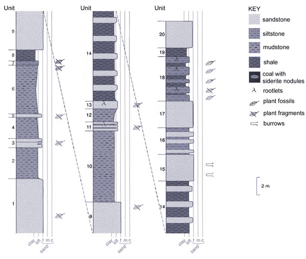
Sedimentary log of the section at Kukpowruk River 96-11 locality. For unit descriptions refer to the panel to the left. |
|
Locality 96-11: 69° 00' 02" N 162° 57' 44" WKukpowruk Formation
|
||
Unit 15. Lenticular sandstone (lens shaped), fine, light gray, weathering to yellow, well bedded. Horizontal "U" shaped burrows. Thickness: 3 m. Unit 16. Poorly indurated brown siltstone interbedded with three fine sandstone layers, the bottom most layer is about 0.1 m thick, the middle is 0.2 m thick, and upper is 0.5 m thick. Thickness: 2.5 to 3 m. Unit 17. Flaggy, lenticular, sandstone (as all the sandstones in the outcrop). Thickness: 3 m. Unit 18. Lumpy interbedded siltstones and claystones containing abundant plant remains that are often minimally fragmented. Birisia alata dominates. There are abundant "Y" shaped roots. 96 RAS 44 to 63. Thickness: about 5 m. Unit 19. Shale. Thickness: 1 m. Unit 20. Sandstone. Thickness: 3 m. Interpretation. The basal portion of this section represents marginal marine facies of varying depth and varying terrigous clastic input. While this section is in most part marine, a blocky/lumpy brown bedded siltstone dipping to the south occurs at the southern end of the outcrop. This contains abundant plant remains, predominantly Birisia alata, as large frond fragments. Equisetites occurs as rhizomes (but some branched aerial parts do occur), together with Parataxodium wigginsii, Arctopteris rarinervis, Heilungia cf. oloensis, Pityophyllum ex gr. staratschinii, and, in the coarser units Ginkgo ex gr. adiantoides. Burial was evidently rapid and frequent as plant remains occur on numerous bedding surfaces over at least three metres of section. Often the plants are preserved cross-cutting bedding planes indicating rapid and repeated influxes of sediment. Birisia fronds are by far the most abundant element and their occurrence adjacent to a marginal marine setting must indicate that Birisia formed coastal "marshes". The sequence is rooted throughout suggesting that after each successive influx of sediment destroyed the marsh vegetation Equisetites and Birisia rapidly recolonised the fresh sediment. Evidently this sequence is a good example of marsh vegetation very close to the shoreline and its is likely that the plants were, to some degree, tolerant of mildly saline, or periodically saline, conditions. The marine units are characterised by predominantly organic rich shales, probably formed in deeper water, interspersed by coarser silts and fine sands exhibiting a variety of ripple forms, mud drapes, worm tracks and Rhizocorallium. No megafaunal remains were seen which possibly indicates a near distributary environment with variable salinity. These silts are mostly devoid of plant remains except water-worn wood fragments. |
||
|
||


