Website Banner


Kukpowruk River

Introduction Geology     Kukpowruk Unassigned Fossils Fossil Images


The map on the right shows the localities along the Kukpowruk River sampled both by Smiley (reported in Smiley 1969a), Spicer and Herman (1996) and by Bob and Andrew Spicer in 1998. Click on the locality numbers to see further details of the sites and the fossil floras.


Map of Kukpowruk River Hotspot linking to Kukpowruk 98RAS17 Hotspot link to Smiley Section C page Link to Map of Smiley's Kukpowruk section D Hotspot linking to page describing Kukpowruk 96 locality 1 Hotspot linking to page describing Kukpowruk 96 locality 2 Hotspot linking to page describing Kukpowruk 96 locality 3 Hotspot linking to page describing Kukpowruk 96 locality 4 Hotspot linking to page describing Kukpowruk 96 locality 5 Hotspot linking to page describing Kukpowruk 96 locality 6 Hotspot linking to page describing Kukpowruk 96 locality 7 Hotspot linking to page describing Kukpowruk 96 locality 8 Hotspot linking to page describing Kukpowruk 96 locality 9 Hotspot linking to page describing Kukpowruk 96 locality 10 Hotspot linking to page describing Kukpowruk 96 locality 11 Hotspot linking to page describing Kukpowruk 96 locality 12 Hotspot linking to page describing Kukpowruk 96 locality 13 Hotspot linking to page describing Kukpowruk 96 locality 14 Hotspot linking to page describing Kukpowruk 96 locality 15 Hotspot linking to page describing Kukpowruk 96 locality 16 Hotspot linking to page describing Kukpowruk 96 locality 17 Hotspot linking to page describing Kukpowruk 96 locality 18 Hotspot linking to page describing Kukpowruk 96 locality 19 Hotspot linking to page describing Kukpowruk 96 locality 20 Hotspot linking to page describing Kukpowruk 96 locality 21 Hotspot linking to page describing Kukpowruk 96 locality 22 Hotspot linking to page describing Kukpowruk 96 locality 23 Hotspot linking to page describing Kukpowruk 96 locality 24 Hotspot linking to page describing Kukpowruk 96 locality 25 Hotspot linking to page describing Kukpowruk 96 locality 26 Hotspot linking to page describing Kukpowruk 96 locality 277 Hotspot linking to Kukpowruk 98RAS16 Hotspot linking to Kukpowruk 98RAS17 Hotspot linking to Kukpowruk 98RAS18 Hotspot linking to Kukpowruk 98RAS19 Hotspot linking to Kukpowruk 98RAS20 Hotspot linking to Kukpowruk 98RAS21 Hotspot linking to Kukpowruk 98RAS22

fieldphotograph of a standing tree stump preserved at Kukpowruk locality 96RAS19


Locality 96-19.  69° 16' 06" N  162° 47' 24" W

Corwin Formation

Specimen: 96 RAS 109, 110a, 110b

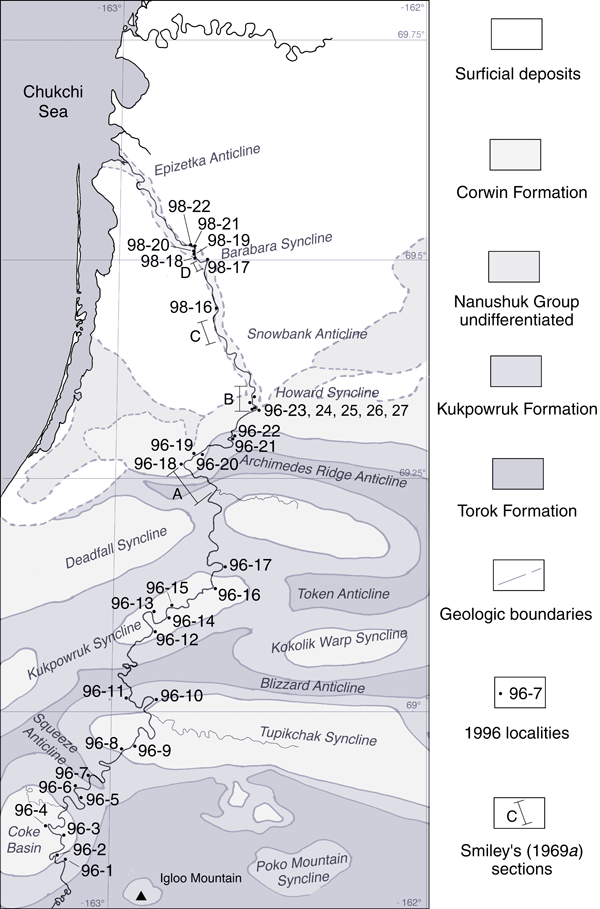
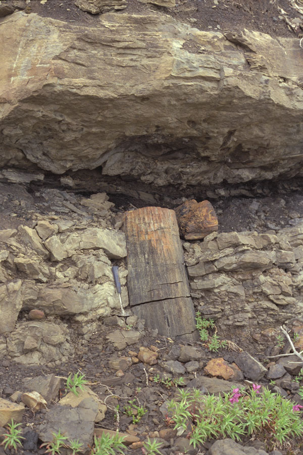
Description. Tree stump 35 - 40 cm diameter, preserved vertical to bedding surrounded by gray/brown silty mudstone with ironstone nodules, lumpy texture, no obvious rooting. The bark of the tree is represented by a coaly layer (96 RAS 109). The ring structure and some cellular detail is apparent in the cross section of the wood (96 RAS 110a, 96 RAS 110b) taken from near the top of the exposed trunk). The bottom of the stump was excavated to a depth of approximately 1 m but the root flair was not reached. The tree was possibly rooted in a dark gray shale that lateral exposures showed underlay the silty mudstone. Ironstone nodules within this shale contained large Pityophyllum and large Podozamites leaves. The silty mudstone became darker gray and more obviously laminated in its upper part before being covered by light gray fine sandstone. The top of the stump was abraded and protruded into a hollow in the underside of this sandstone.

Interpretation. An in situ tree (see below and below right) rooted in Nanushuk floodplain soils inundated by two episodes of crevasse splay deposition, the second being more proximal to the channel than the first. The period between crevasse splay events was sufficient for partial rotting of the exposed portion of the buried stump to take place. This partly rotted portion of the stump was abraded by the second sand inundation.


Right: The well preserved standing conifer tree base that was the source of samples 96 RAS 109 and 110.


Below: The same tree with the base partly excavated.


Photograph of the tree base partially excavated