Website Banner


Lower Colville River, Locality 86/24

Northern Alaska Map          


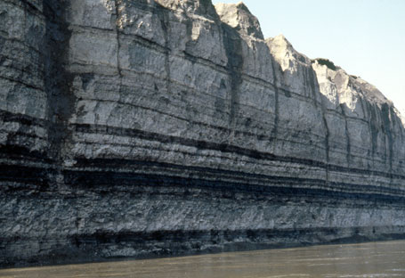
Uluksrak Bluff. The exposure here was vertical and constantly collapsing due to undercutting by the river. Sampling was not possible.

Photograph of the Uluksrak Bluffs exposure
 
Uluksrak Bluff


  Map of the colville River below Umiat Hotspot linking to page describing locality 86/21 Hotspot linking to page describing locality86/22 Hotspot linking to page describing locality 86/23 Hotspot linking to page describing locality 86/24 Hotspot linking to page describing locality 86?25 Hotspot linking to a page describing locality 86/26 Hotspot linking to a page describing locality 86/27 Hotspot linking to a page describing locality 86/28 Hotspot linking to a page describing locality 86/29 Hotspot linking to a page describing locality 30 Hotspot linking to a page describing locality 86/31 Hotspot linking to a page describing locality 86/32 Hotspot linking to a page describing locality  86/33 Hotspot linking to a page describing locality  86/34 Hotspot linking to a page describing locality  86/35 Hotspot linking to a page describing locality  86/36 Hotspot linking to a page describing locality  86/37 Hotspot linking to a page describing locality 86/38 Hotspot linking to a page describing locality 86/39 Hotspot linking to a page describing locality  86/40 Hotspot linking to a page describing locality  86/41 Hotspot linking to a page describing locality  86/42 Hotspot linking to a page describing locality  86/43 Hotspot linking to a page describing locality  86/44 Hotspot linking to a page describing locality  86/45 Hotspot linking to a page describing locality 86/46 Hotspot linking to a page describing locality 86/47 Hotspot linking to a page describing locality 86/48 Hotspot linking to a page describing locality 86/50 Hotspot linking to a page describing locality 86/52 Hotspot linking to a page describing locality 86/53 Hotspot linking to a page describing locality 86/55 Hotspot linking to a page describing locality 86/57 Hotspot linking to a page describing locality 86/59 Hotspot linking to a page describing locality 86/60 Hotspot linking to a page describing Smiley's locality Co. 49 Hotspot linking to a page describing Smiley's locality Col. 50 Hotspot linking to a page describing Smiley's locality Col. 51 Hotspot linking to a page describing Smiley's locality Col. 52 Hotspot linking to a page describing Smiley's locality Col. 54_55
  Interactive map of the lower reaches of the Colville River showing plant fossil localities sampled by Smiley (1969) and by Parrish and Spicer in 1986.
     
Field photograph from the air showing exposures of the Prince Creek Formation along the western side of the Colville River
 
Part of the exposure of the Prince Creek Formation (formerly the Kogosukruk Tongue of the Prince Creek Formation) on the western side of the Colville River between Uluksrak Bluff and Ocean Point.


Hotspot linking to page describing locality 86/21 Hotspot linking to page describing locality86/22 Hotspot linking to page describing locality 86/23 Hotspot linking to page describing locality 86/24