Website Banner


Lower Colville River, Locality 86/46

Northern Alaska Map          


Kogosukruk Tongue of the Prince Creek Formation. The base of the exposed part of the section consist of a dark gray-olive mudstone at least 1.7 m thick containing dispersed plant fragments and Equisetites rhizomes with nodules. This unit coarsens up into a gray siltstone and becomes more indurated and greenish-gray with ripple marks and rare wood impressions. This more indurated siltstone is approximately 45 cm in thickness and is overlain by a dark olive gray mud (approximately 1.5 m thick) with abundant carbonaceous debris and Equisetites rhizomes. The Equisetites remains are concentrated in two horizons, one at about 1 m from the base of the unit and one near the top. At the top of the unit the mudstone gives way to a dark sticky clay (5 cm thick) overlain by a 1.5 cm thick sand layer with abundant plant debris and twigs. This is in turn overlain by a dark gray sticky siltstone approximately 1.3 m thick before being covered at the top of the section.

No megafossils were collected or photographed.

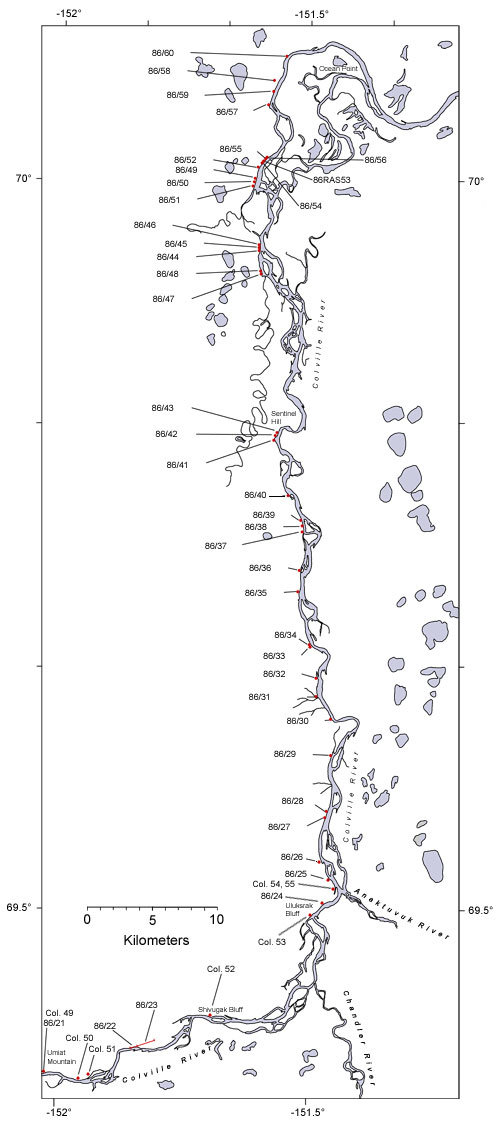
  Map of the colville River below Umiat Hotspot linking to page describing locality 86/21 Hotspot linking to page describing locality86/22 Hotspot linking to page describing locality 86/23 Hotspot linking to page describing locality 86/24 Hotspot linking to page describing locality 86?25 Hotspot linking to a page describing locality 86/26 Hotspot linking to a page describing locality 86/27 Hotspot linking to a page describing locality 86/28 Hotspot linking to a page describing locality 86/29 Hotspot linking to a page describing locality 30 Hotspot linking to a page describing locality 86/31 Hotspot linking to a page describing locality 86/32 Hotspot linking to a page describing locality  86/33 Hotspot linking to a page describing locality  86/34 Hotspot linking to a page describing locality  86/35 Hotspot linking to a page describing locality  86/36 Hotspot linking to a page describing locality  86/37 Hotspot linking to a page describing locality 86/38 Hotspot linking to a page describing locality 86/39 Hotspot linking to a page describing locality  86/40 Hotspot linking to a page describing locality  86/41 Hotspot linking to a page describing locality  86/42 Hotspot linking to a page describing locality  86/43 Hotspot linking to a page describing locality  86/44 Hotspot linking to a page describing locality  86/45 Hotspot linking to a page describing locality 86/46 Hotspot linking to a page describing locality 86/47 Hotspot linking to a page describing locality 86/48 Hotspot linking to a page describing locality 86/50 Hotspot linking to a page describing locality 86/52 Hotspot linking to a page describing locality 86/53 Hotspot linking to a page describing locality 86/55 Hotspot linking to a page describing locality 86/57 Hotspot linking to a page describing locality 86/59 Hotspot linking to a page describing locality 86/60 Hotspot linking to a page describing Smiley's locality Co. 49 Hotspot linking to a page describing Smiley's locality Col. 50 Hotspot linking to a page describing Smiley's locality Col. 51 Hotspot linking to a page describing Smiley's locality Col. 52 Hotspot linking to a page describing Smiley's locality Col. 54_55
  Interactive map of the lower reaches of the Colville River showing plant fossil localities sampled by Smiley (1969) and by Parrish and Spicer in 1986.
     
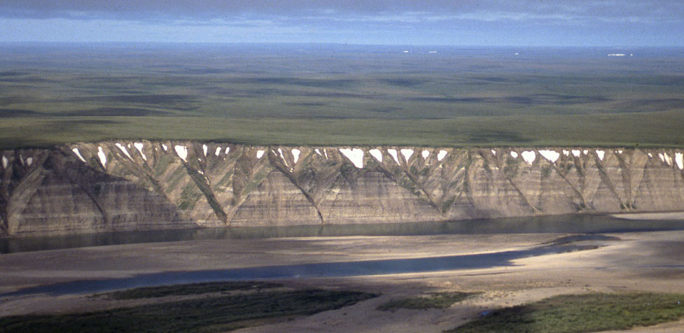
Field photograph from the air showing exposures of the Prince Creek Formation along the western side of the Colville River
 
Part of the exposure of the Prince Creek Formation (formerly the Kogosukruk Tongue of the Prince Creek Formation) on the western side of the Colville River between Uluksrak Bluff and Ocean Point.


Hotspot linking to page describing locality 86/21 Hotspot linking to page describing locality86/22 Hotspot linking to page describing locality 86/23 Hotspot linking to page describing locality 86/24 Hotspot linking to page describing locality 86?25 Hotspot linking to a page describing locality 86/26 Hotspot linking to a page describing locality 86/27 Hotspot linking to a page describing locality 86/28 Hotspot linking to a page describing locality 86/29 Hotspot linking to a page describing locality 30 Hotspot linking to a page describing locality 86/31 Hotspot linking to a page describing locality 86/32 Hotspot linking to a page describing locality  86/33 Hotspot linking to a page describing locality  86/34 Hotspot linking to a page describing locality  86/35 Hotspot linking to a page describing locality  86/36 Hotspot linking to a page describing locality  86/37 Hotspot linking to a page describing locality 86/38 Hotspot linking to a page describing locality 86/39 Hotspot linking to a page describing locality  86/40 Hotspot linking to a page describing locality  86/41 Hotspot linking to a page describing locality  86/42 Hotspot linking to a page describing locality  86/43 Hotspot linking to a page describing locality  86/44 Hotspot linking to a page describing locality  86/45 Hotspot linking to a page describing locality 86/46