Website Banner


Lower Colville River, Locality 86/47

Northern Alaska Map          


Kogosukruk Tongue of the Prince Creek Formation. Compressed wood in situ (wood sample 86RAS176) in a gray siltstone coarsening slightly to a sandstone at the top. The siltstone is above a coal with a prominent white band (bentonitic clay?) in the centre. Just laterally from the wood accumulation the siltsone contains conifer needles (Parataxodium?) (86RAS177).

Compressed wood in situ (wood sample 86RAS176) in a gray siltstone coarsening slightly to a sandstone at the top. The siltstone is above a coal with a prominent white band (bentonitic clay?) in the centre. Just laterally from the wood accumulation the siltstone contains conifer needles (Parataxodium?, 86RAS177).

The fine sandstone mentioned above (approximately 40 cm thick) fines upwards to a rooted silt capped by a thin (2.5 cm) rooted white clay, which is in turn overlain by a dark gray mud (5 cm thick) containing abundant fusain. This is overlain by a 20 cm thick rooted beige mudstone containing carbonaceous debris, which in turn is overlain by a 10 cm thick dirty coal. Above this is a 7.5 cm thick light gray rooted bentonitic clay forming a prominent 'white' band, underlying a 7.5 cm thick coal. This coal is capped by a 2.5 cm thick bentonitic clay containing conifer (Parataxodium) leaves, underlying another thin (5 cm thick) coal. This is interpreted as an ash fall interupting peat deposition and provides an insight into the composition of the peat forming forest.

Overlying this coal is an olive-gray mudstone with abundant wood. Approximately 1.7 m above the coal is an ironstone layer containing some unidentifiable plant fragments.

No leaf megafossils were photographed.

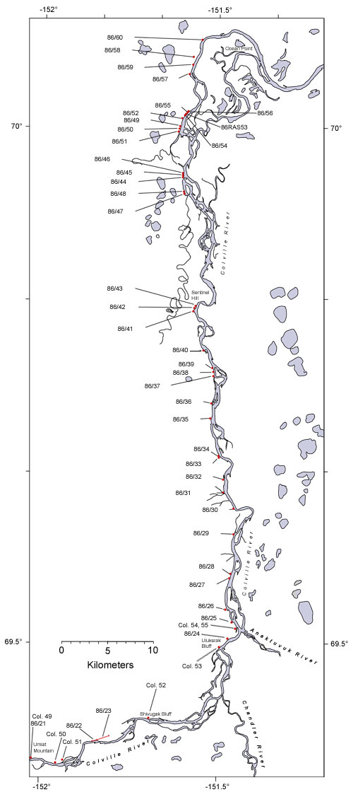
  Map of the colville River below Umiat Hotspot linking to page describing locality 86/21 Hotspot linking to page describing locality86/22 Hotspot linking to page describing locality 86/23 Hotspot linking to page describing locality 86/24 Hotspot linking to page describing locality 86?25 Hotspot linking to a page describing locality 86/26 Hotspot linking to a page describing locality 86/27 Hotspot linking to a page describing locality 86/28 Hotspot linking to a page describing locality 86/29 Hotspot linking to a page describing locality 30 Hotspot linking to a page describing locality 86/31 Hotspot linking to a page describing locality 86/32 Hotspot linking to a page describing locality  86/33 Hotspot linking to a page describing locality  86/34 Hotspot linking to a page describing locality  86/35 Hotspot linking to a page describing locality  86/36 Hotspot linking to a page describing locality  86/37 Hotspot linking to a page describing locality 86/38 Hotspot linking to a page describing locality 86/39 Hotspot linking to a page describing locality  86/40 Hotspot linking to a page describing locality  86/41 Hotspot linking to a page describing locality  86/42 Hotspot linking to a page describing locality  86/43 Hotspot linking to a page describing locality  86/44 Hotspot linking to a page describing locality  86/45 Hotspot linking to a page describing locality 86/46 Hotspot linking to a page describing locality 86/47 Hotspot linking to a page describing locality 86/48 Hotspot linking to a page describing locality 86/50 Hotspot linking to a page describing locality 86/52 Hotspot linking to a page describing locality 86/53 Hotspot linking to a page describing locality 86/55 Hotspot linking to a page describing locality 86/57 Hotspot linking to a page describing locality 86/59 Hotspot linking to a page describing locality 86/60 Hotspot linking to a page describing Smiley's locality Co. 49 Hotspot linking to a page describing Smiley's locality Col. 50 Hotspot linking to a page describing Smiley's locality Col. 51 Hotspot linking to a page describing Smiley's locality Col. 52 Hotspot linking to a page describing Smiley's locality Col. 54_55
  Interactive map of the lower reaches of the Colville River showing plant fossil localities sampled by Smiley (1969) and by Parrish and Spicer in 1986.
     
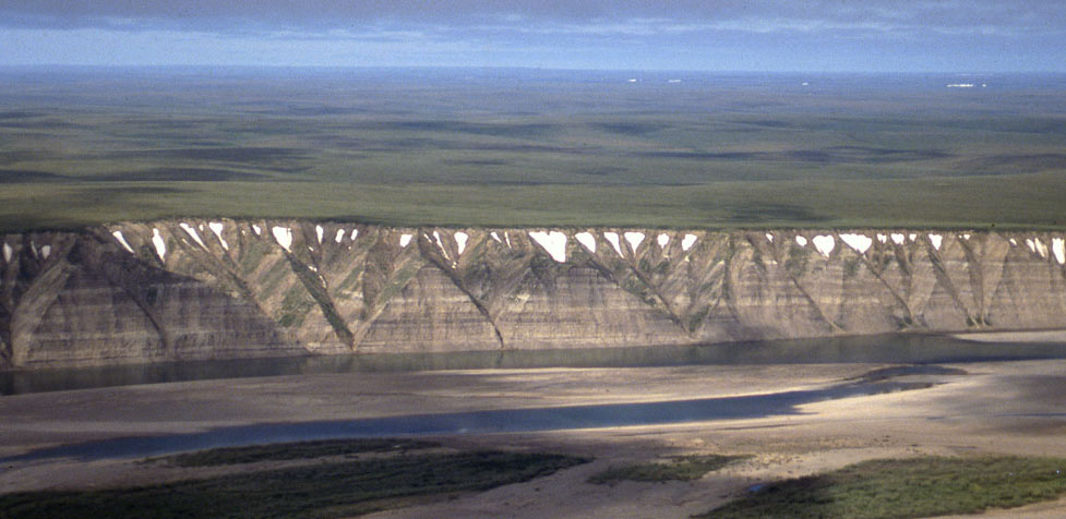
Field photograph from the air showing exposures of the Prince Creek Formation along the western side of the Colville River
 
Part of the exposure of the Prince Creek Formation (formerly the Kogosukruk Tongue of the Prince Creek Formation) on the western side of the Colville River between Uluksrak Bluff and Ocean Point.


Hotspot linking to page describing locality 86/21 Hotspot linking to page describing locality86/22 Hotspot linking to page describing locality 86/23 Hotspot linking to page describing locality 86/24 Hotspot linking to page describing locality 86?25 Hotspot linking to a page describing locality 86/26 Hotspot linking to a page describing locality 86/27 Hotspot linking to a page describing locality 86/28 Hotspot linking to a page describing locality 86/29 Hotspot linking to a page describing locality 30 Hotspot linking to a page describing locality 86/31 Hotspot linking to a page describing locality 86/32 Hotspot linking to a page describing locality  86/33 Hotspot linking to a page describing locality  86/34 Hotspot linking to a page describing locality  86/35 Hotspot linking to a page describing locality  86/36 Hotspot linking to a page describing locality  86/37 Hotspot linking to a page describing locality 86/38 Hotspot linking to a page describing locality 86/39 Hotspot linking to a page describing locality  86/40 Hotspot linking to a page describing locality  86/41 Hotspot linking to a page describing locality  86/42 Hotspot linking to a page describing locality  86/43 Hotspot linking to a page describing locality  86/44 Hotspot linking to a page describing locality  86/45 Hotspot linking to a page describing locality 86/46 Hotspot linking to a page describing locality 86/47