Website Banner


Lower Colville River, Locality 86/52

Northern Alaska Map          


Kogosukruk Tongue of the Prince Creek Formation. Down river from the mouth of Kikiakorak Creek. A thick crossbedded siltsone/sandstone unit gives way upsection to several carbonaceous bands interbedded with mudstones.

The bottom of the mudstone succession consists of a dark gray carbonaceous shale overlain by a 10 cm thick papery coal that gives way to a thicker (15 cm) more indurated coal containing impressions of twigs. Overlying this is a 25 cm thick chocolate colored clay containing conifer needles, Equisetites rhizomes and fruits of unknown affinity. This is capped by a 2.5 cm thick bentonite overlain by a25 cm thick light gray bentonitic clay with abundant plant fragments. Above this is a dark gray clay, 20 cm thick, overlain by a 5 cm thick seat earth to a coal, initially brownish becoming more bituminous in the centre and brownish again at the top. The total thickness of this coal is about 15 cm and gives way to a thin bentonitic chocolate brown mudstone (30 cm thick) with abundant plant debris. The top of this unit is rooted and is a chocolate brown clay (75 cm) overlain by an olive gray clay with Equisetites rhizomes.

Above this olive gray clay is a grayer, siltier, clay some 90 cm thick that is rooted at the top. This is overlain by a 28 cm thick bituminous coal containing branchwood, overlain by a 45 cm thick brown mudstone.

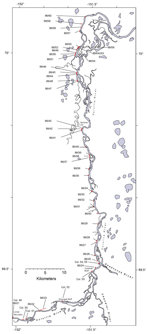
  Map of the colville River below Umiat Hotspot linking to page describing locality 86/21 Hotspot linking to page describing locality86/22 Hotspot linking to page describing locality 86/23 Hotspot linking to page describing locality 86/24 Hotspot linking to page describing locality 86?25 Hotspot linking to a page describing locality 86/26 Hotspot linking to a page describing locality 86/27 Hotspot linking to a page describing locality 86/28 Hotspot linking to a page describing locality 86/29 Hotspot linking to a page describing locality 30 Hotspot linking to a page describing locality 86/31 Hotspot linking to a page describing locality 86/32 Hotspot linking to a page describing locality  86/33 Hotspot linking to a page describing locality  86/34 Hotspot linking to a page describing locality  86/35 Hotspot linking to a page describing locality  86/36 Hotspot linking to a page describing locality  86/37 Hotspot linking to a page describing locality 86/38 Hotspot linking to a page describing locality 86/39 Hotspot linking to a page describing locality  86/40 Hotspot linking to a page describing locality  86/41 Hotspot linking to a page describing locality  86/42 Hotspot linking to a page describing locality  86/43 Hotspot linking to a page describing locality  86/44 Hotspot linking to a page describing locality  86/45 Hotspot linking to a page describing locality 86/46 Hotspot linking to a page describing locality 86/47 Hotspot linking to a page describing locality 86/48 Hotspot linking to a page describing locality 86/50 Hotspot linking to a page describing locality 86/52 Hotspot linking to a page describing locality 86/53 Hotspot linking to a page describing locality 86/55 Hotspot linking to a page describing locality 86/57 Hotspot linking to a page describing locality 86/59 Hotspot linking to a page describing locality 86/60 Hotspot linking to a page describing Smiley's locality Co. 49 Hotspot linking to a page describing Smiley's locality Col. 50 Hotspot linking to a page describing Smiley's locality Col. 51 Hotspot linking to a page describing Smiley's locality Col. 52 Hotspot linking to a page describing Smiley's locality Col. 54_55
  Interactive map of the lower reaches of the Colville River showing plant fossil localities sampled by Smiley (1969) and by Parrish and Spicer in 1986.
     
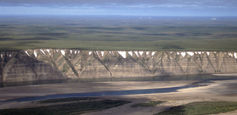
Field photograph from the air showing exposures of the Prince Creek Formation along the western side of the Colville River
 
Part of the exposure of the Prince Creek Formation (formerly the Kogosukruk Tongue of the Prince Creek Formation) on the western side of the Colville River between Uluksrak Bluff and Ocean Point.


Hotspot linking to page describing locality 86/21 Hotspot linking to page describing locality86/22 Hotspot linking to page describing locality 86/23 Hotspot linking to page describing locality 86/24 Hotspot linking to page describing locality 86?25 Hotspot linking to a page describing locality 86/26 Hotspot linking to a page describing locality 86/27 Hotspot linking to a page describing locality 86/28 Hotspot linking to a page describing locality 86/29 Hotspot linking to a page describing locality 30 Hotspot linking to a page describing locality 86/31 Hotspot linking to a page describing locality 86/32 Hotspot linking to a page describing locality  86/33 Hotspot linking to a page describing locality  86/34 Hotspot linking to a page describing locality  86/35 Hotspot linking to a page describing locality  86/36 Hotspot linking to a page describing locality  86/37 Hotspot linking to a page describing locality 86/38 Hotspot linking to a page describing locality 86/39 Hotspot linking to a page describing locality  86/40 Hotspot linking to a page describing locality  86/41 Hotspot linking to a page describing locality  86/42 Hotspot linking to a page describing locality  86/43 Hotspot linking to a page describing locality  86/44 Hotspot linking to a page describing locality  86/45 Hotspot linking to a page describing locality 86/46 Hotspot linking to a page describing locality 86/47 Hotspot linking to a page describing locality 86/48 Hotspot linking to a page describing locality 86/50 Hotspot linking to a page describing locality 86/52