Website Banner


Lower Colville River, Locality 86/56

Northern Alaska Map         Leaf Fossils


Kogosukruk Tongue of the Prince Creek Formation. Ironstone float, apparently the same horizon as that at locality 86/53. The ironstone contains Equisetites rhizomes, numerous Phragmites fragments, fragments of conifer leaves (Parataxodium?) and Quereuxia. The overlying sandstone here is muddier at the base with only faint cross beds and not throughout. This unit is rooted throughout. About 1.6 m above the coal horizon seen at previous localities is the upper part of this muddy rooted bed, which has an undulating (erosional) bed. The sediments above contains rip up clasts of the underlying muddy unit together with wood and other plant fragments. The middle part of the sandstone is strongly cross bedded with pebble lenses. The upper third of the sandstone is flat bedded or with broad low angle cross beds. This upper part of the sandstone grades into a brown sandy clay over a thickness of approximately 90 cm before passing into a 10 cm thick brown 'coal' overlain by 30 cm of brown sand which passes into a darker brown sandy mudstone and then into a very unconsolidated grays and with carbonaceous laminae.

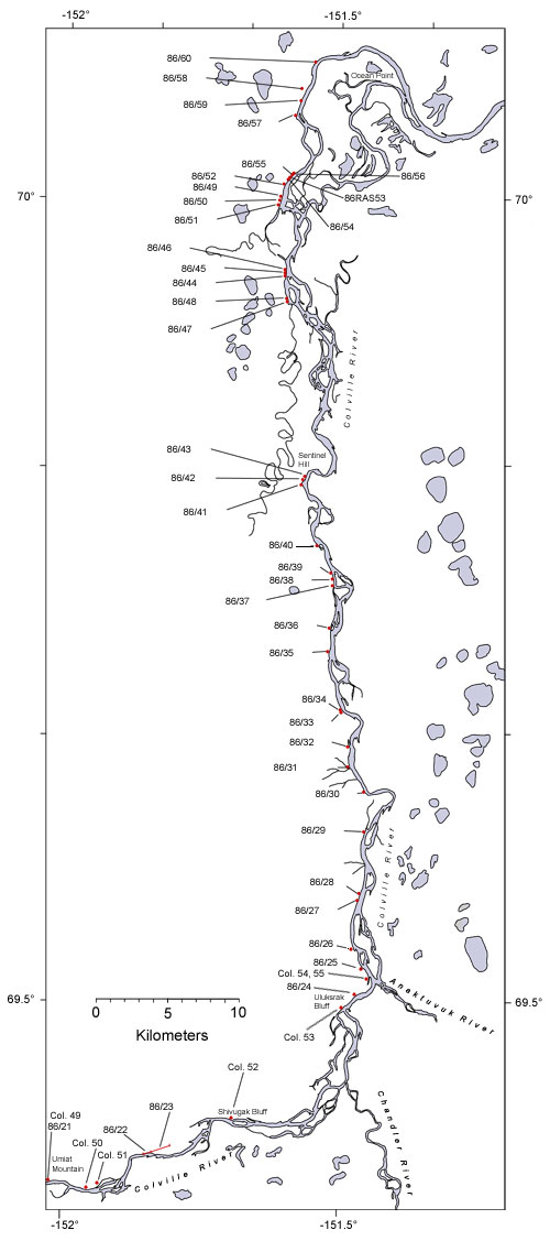
  Map of the colville River below Umiat Hotspot linking to page describing locality 86/21 Hotspot linking to page describing locality86/22 Hotspot linking to page describing locality 86/23 Hotspot linking to page describing locality 86/24 Hotspot linking to page describing locality 86?25 Hotspot linking to a page describing locality 86/26 Hotspot linking to a page describing locality 86/27 Hotspot linking to a page describing locality 86/28 Hotspot linking to a page describing locality 86/29 Hotspot linking to a page describing locality 30 Hotspot linking to a page describing locality 86/31 Hotspot linking to a page describing locality 86/32 Hotspot linking to a page describing locality  86/33 Hotspot linking to a page describing locality  86/34 Hotspot linking to a page describing locality  86/35 Hotspot linking to a page describing locality  86/36 Hotspot linking to a page describing locality  86/37 Hotspot linking to a page describing locality 86/38 Hotspot linking to a page describing locality 86/39 Hotspot linking to a page describing locality  86/40 Hotspot linking to a page describing locality  86/41 Hotspot linking to a page describing locality  86/42 Hotspot linking to a page describing locality  86/43 Hotspot linking to a page describing locality  86/44 Hotspot linking to a page describing locality  86/45 Hotspot linking to a page describing locality 86/46 Hotspot linking to a page describing locality 86/47 Hotspot linking to a page describing locality 86/48 Hotspot linking to a page describing locality 86/50 Hotspot linking to a page describing locality 86/52 Hotspot linking to a page describing locality 86/53 Hotspot linking to a page describing locality 86/55 Hotspot linking to a page describing locality 86/57 Hotspot linking to a page describing locality 86/59 Hotspot linking to a page describing locality 86/60 Hotspot linking to a page describing Smiley's locality Co. 49 Hotspot linking to a page describing Smiley's locality Col. 50 Hotspot linking to a page describing Smiley's locality Col. 51 Hotspot linking to a page describing Smiley's locality Col. 52 Hotspot linking to a page describing Smiley's locality Col. 54_55
  Interactive map of the lower reaches of the Colville River showing plant fossil localities sampled by Smiley (1969) and by Parrish and Spicer in 1986.
     
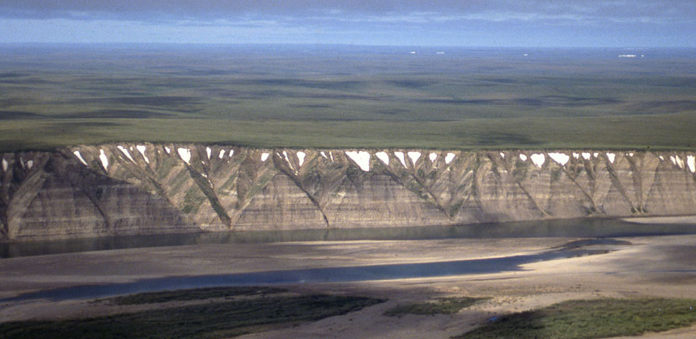
Field photograph from the air showing exposures of the Prince Creek Formation along the western side of the Colville River
 
Part of the exposure of the Prince Creek Formation (formerly the Kogosukruk Tongue of the Prince Creek Formation) on the western side of the Colville River between Uluksrak Bluff and Ocean Point.


Hotspot linking to page describing locality 86/21 Hotspot linking to page describing locality86/22 Hotspot linking to page describing locality 86/23 Hotspot linking to page describing locality 86/24 Hotspot linking to page describing locality 86?25 Hotspot linking to a page describing locality 86/26 Hotspot linking to a page describing locality 86/27 Hotspot linking to a page describing locality 86/28 Hotspot linking to a page describing locality 86/29 Hotspot linking to a page describing locality 30 Hotspot linking to a page describing locality 86/31 Hotspot linking to a page describing locality 86/32 Hotspot linking to a page describing locality  86/33 Hotspot linking to a page describing locality  86/34 Hotspot linking to a page describing locality  86/35 Hotspot linking to a page describing locality  86/36 Hotspot linking to a page describing locality  86/37 Hotspot linking to a page describing locality 86/38 Hotspot linking to a page describing locality 86/39 Hotspot linking to a page describing locality  86/40 Hotspot linking to a page describing locality  86/41 Hotspot linking to a page describing locality  86/42 Hotspot linking to a page describing locality  86/43 Hotspot linking to a page describing locality  86/44 Hotspot linking to a page describing locality  86/45 Hotspot linking to a page describing locality 86/46 Hotspot linking to a page describing locality 86/47 Hotspot linking to a page describing locality 86/48 Hotspot linking to a page describing locality 86/50 Hotspot linking to a page describing locality 86/52 Hotspot linking to a page describing locality 86/53 Hotspot linking to a page describing locality 86/55