
Upper Colville River, Alaska
| Upper Colville Fossil Images Unassigned | Fossil Images 85JTP01 |
|---|
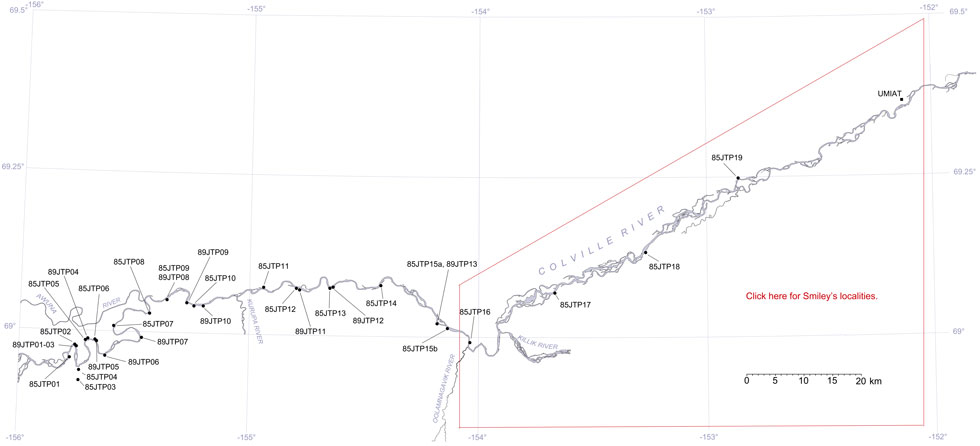
This interactive map of part of the Colville River, Northern Alaska, shows the locations of plant fossil collections made by J.T. Parrish and R.A. Spicer in 1985 and 1989. Click on a number for more details on that site. The red outlined area links to another map showing positions of florules (plant fossil assemblages) collected by C.J. Smiley along both the Colville and Chandler Rivers. |
Locality 85JTP01
This section is mapped as KcKt (lower part of the Killik Tongue of the Chandler Formation and Tuktu Formation undifferentiated, Chapman et al., 1964), now the middle part of the Nanushuk Formation (Mull et al., 2003).
The upper part of the section is a rippled marine sandstone with some mud drapes, which show abundant trace fossils, flow marks, and a poorly preserved bivalve. The lower part is predominantly mudstone with coal stringers overlain by channel deposits with a basal conglomerate. Within the mudstone, which contains abundant plant remains consists of a succession of well-bedded lenses of mudstones, fine sands and shales with some ironstone concretionary horizons. This is overlain by dark gray nodular shale with fine sand and mudstone horizons, which in turn is overlain by cross-bedded sandstones with basal pebble lags. This is interpreted as a channel fill. The plant remains present in the succession is Podozamites, conifer leafy shoots and ferns. Some large logs occur in the base of the channel.
The exposure represents the upper part of a major sandstone body that passes laterally into siltstones with iron concretions containing Ginkgo, Podozamites and long-leaved conifers of the Pityophyllum type.
An overview of the non-marine part of the section, divided into three units, was recorded by J.T. Parrish on July 8 1985.
| Top of section | ||
| Approximately 6m | shallow marine sandstone. | |
| Approx. 12 m covered | ||
| Unit 1 | 5.2 m 1.5 m |
medium to fine-grained crossbedded sandstone medium cross bedded sandstone with conglomerate stringers grades laterally into siltsones with ironstone layers containing Ginkgo. |
| Unit 2 | 3.4 m | conglomeratic, very coarse sand, with large logs and a deeply scoured base to the north, slightly finer, lacking logs and deep scours to the south. |
| Unit 3 | 7.8 m | Siltstones and mudstones, very poorly bedded, ironstained concretions and layers, clayey beds very thin, abundant plant material. |
| Bottom of Section |