
Upper Colville River, Alaska
| Upper Colville Fossil Images Unassigned | Fossil Images 85JTP09 |
|---|
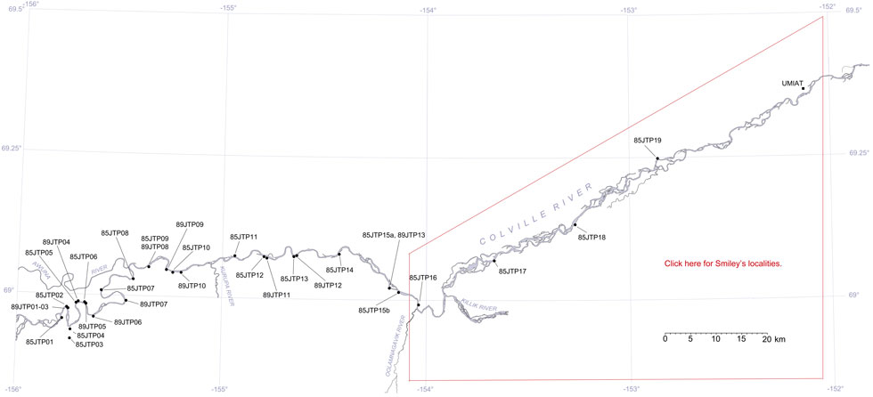
This interactive map of part of the Colville River, Northern Alaska, shows the locations of plant fossil collections made by J.T. Parrish and R.A. Spicer in 1985 and 1989. Click on a number for more details on that site. The red outlined area links to another map showing positions of florules (plant fossil assemblages) collected by C.J. Smiley along both the Colville and Chandler Rivers. |
Locality 85JTP09
This locality is an exposure of the Cenomanian Niakogan and Upper Killik tongues of the Chandler Formation of Chapman et al. (1964), now the upper part of the Nanushuk Formation of Mull et al. (2003). The sediments are predominantly bentonitic clays with siderite nodules, coals and fine sandstones. The plant fossils are mostly found in the ironstone which occurs both as sheets and nodules, but platanoid leaves occur in the sandstones. The ironstone flora is dominated by taxodioid conifers, highly dissected forms of Ginkgo and ferns. Some angiosperms such as Dalembia also occur. Wood is mostly represented by log impressions, but some structurally preserved material does occur. None of the wood seen was in growth position. This locality also yielded freshwater bivalve with bite marks and a steinkern of a turtle, both were described in Parrish et al. (1987).
The section is generally not well exposed and most of the material was recovered from float. A coal was exposed at beach level when visited in 1985. This was underlain and overlain by a carbonaceous shale. The overlying shale is thin (5 cm) and more indurated than that below. Overlying this shale was a 3 cm thick papery coal followed by a 15 cm thick more indurated and blocky coal. Above this the coal became papery and then more blocky again before being covered by approximately 1.5 m of bentonitic clay. The section resumed with approximately 30 cm of blocky coal, 5 cm of shaley coal and then 15 cm of papery carbonaceous shale. Conifers found as float, but associated with the coals, were mostly Cephalototaxopsis and Podozamites.
The contact between the Niakogon and Upper Killik Tongues of the Nanushuk Formation is not at all clear but occurs in this section towards it's eastern end. Here a diverse flora was found in ironstones (samples 85RAS 99-106) with poorly preserved platanoid angiosperms sometimes occurring in friable sandstones. The ironstones occur in weathered bentonitic mudstones that probably represent accumulations in lakes. Preservation was likely to have been enhanced by significant influxes of volcanic ash. Numerous casts of logs up to 0.5 m in diameter also occur in the sandstones, which evidently represent river channel fills. Equisetites rhizomes abound in yellow-weathering ironstones.
The following is a summary of lithologies found at Locality 85JTP09 made by J.T.Parrish in July 1985.
| Top of section | ||
| Sandstone | ||
| Approx. 8 m | Bentonitic mudstone | |
| 0.75 m | Sandstone | |
| 1.5 m | Bentonitic mudstone | |
| 2.3 m | Coal | |
| Approx 8 m | Bentonitic mudstone with ironstone concretions | |
| 0.3 m | Conretionary ironstone layer | |
| 0.9 m | Bentonitic mudstone | |
| 0.38 m | Concretionary ironstone layer | |
| 0.025 m | Black paper shale | |
| 1.2 m | Bentonitic mudstone | |
| 1.2 m thinning to 0.45 m | Lenticular sandstone | |
| 0.18 m | Concretionary ironstone layer | |
| 0.75 m | Bentonitic mudstone | |
| 0.15 m | Siltstone | |
| 0.3 m | Concretionary ironstone layer with fern fossils | |
| 1.7 m | Bentonitic mudstone | |
| 0.3 m | Sandstone | |
| 3.6 m | Bentonitic mudstone with ironstone concretionary layer | |
| 7.6 m | Sandstone | |
| Silty sandstone |
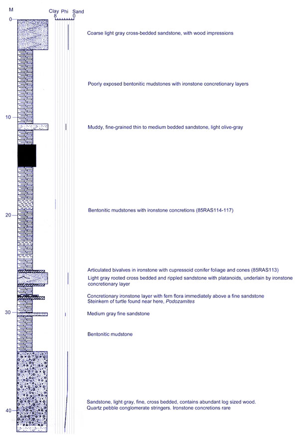 |
Lithological column of locality 85JTP09 based on observations of J.T. Parrish made in July 1985. |