
Upper Colville River, Alaska
| Upper Colville Fossil Images Unassigned | Fossil Images 85JTP13 |
|---|
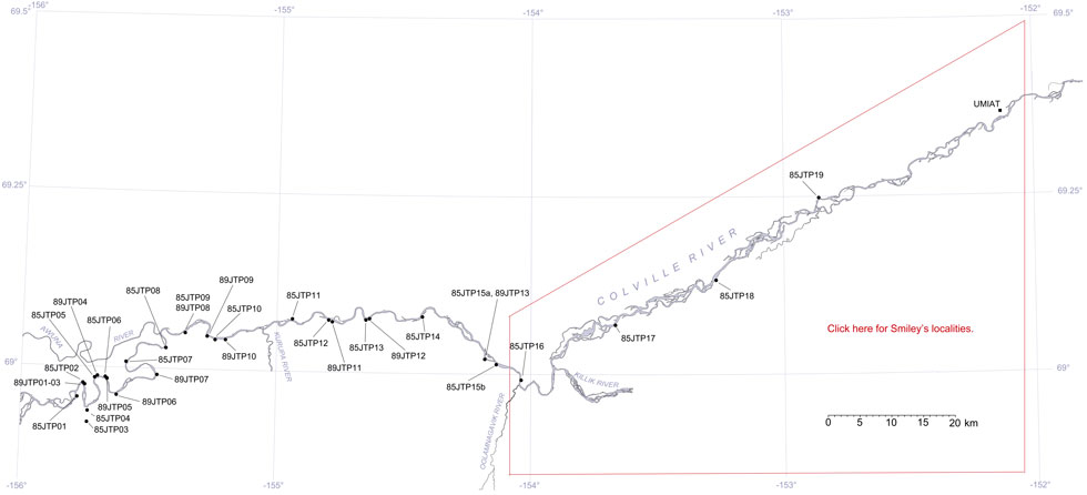
This interactive map of part of the Colville River, Northern Alaska, shows the locations of plant fossil collections made by J.T. Parrish and R.A. Spicer in 1985 and 1989. Click on a number for more details on that site. The red outlined area links to another map showing positions of florules (plant fossil assemblages) collected by C.J. Smiley along both the Colville and Chandler Rivers. |
Locality 85JTP13
This exposure is mapped as the Lower Killik of the Chandler Formation (Chapman et al., 1964), now the upper part of the laower half of the Nanushuk Formation of Mull et al. (2003). Here a carbonaceous siltstone is exposed near the base of the section and this underlies a coal approximately 1.3 m thick. Most of the plant fossils were collected from tabular ironstone concretions that crop out at river level. Taxa present include entire-margined cycads (Nilssonia yukonensis), ginkgos, Podozamites, and Gleichenites.
Lithologies as summarised by J.T. Parrish in July 1985.
| Top of Section | ||
| 2.4 m | Thin to medium bedded very fine sandstone weathering gray and orange, some silty horizons present, rippled with finely disseminated plant material | |
| Approx. 1 m | Cover | |
| 1.3 m | Coal with very large ironstone concretions | |
| 4.5 - 6 m | Medium dark gray siltstone and silty mudstone with black coaly paper shale in some horizons and coaly stringers (presumably compressed logs). Abundant large and small ironstone concretions containing plant fossils such as Cephalotaxopsis, Podozamites, angiosperms, cycads and ferns. | |
| 0.6 m | Pale yellow-orange concretionary layer | |
| 2.4 m | Olive gray bentonitic silty claystone excavated from what is basically cover. Abundant pale yellowish-orange concretionary lenses. | |
| 6.1 m | Bentonitic very fine medium to light gray sandstone, thin to medium bedded, with abundant ironstone lenses and concretions. | |
| 6 m | Covered by bentonitic slope wash. | |
| 1 m | Ironstone concretionary layer, yellow-weathering, cropping out at river level containing cycads, ginkgos, Podozamites etc. |
Downstream further outcrops suggest that the basal ironstone layer is underlain by a bentonitic sandstone totalling 18 m in thickness, below which is a 3.5 m thick dark gray mudstone, a concretionary layer and a coal.