Website Banner


Upper Colville River, Alaska

        Upper Colville Fossil Images Unassigned No fossils collected


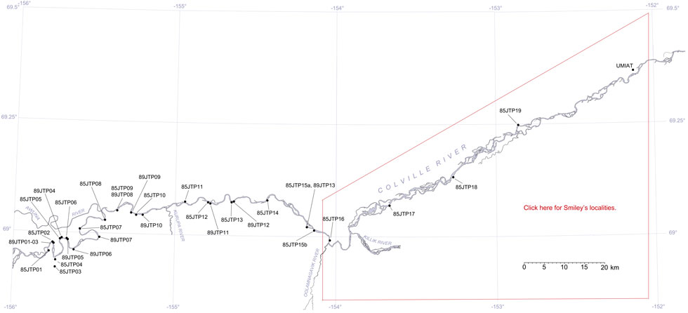
This interactive map of part of the Colville River, Northern Alaska, shows the locations of plant fossil collections made by J.T. Parrish and R.A. Spicer in 1985 and 1989. Click on a number for more details on that site. The red outlined area links to another map showing positions of florules (plant fossil assemblages) collected by C.J. Smiley along both the Colville and Chandler Rivers.

Interactive map of the Upper Colville River Hotspot linking to 85RAS09 Hotspot linking to Smiley's Colville and Chandler River localities. Hotspot linking to 85RAS02 Hotspot linking to 85RAS01 Hotspot linking to 85RAS03 Hotspot linking to 85RAS04 Hotspot linking to 85RAS05 Hotspot linking to 85RAS06 Hotspot linking to 85RAS07  Hotspot linking to 85RAS08 Hotspot linking to 85RAS10 Hotspot linking to 85RAS11 Hotspot linking to 85RAS12 Hotspot linking to 85RAS13 Hotspot linking to 85RAS14 Hotspot linking to 85RAS13 Hotspot linking to 85RAS16 Hotspot linking to 85RAS17 Hotspot linking to 85RAS18 Hotspot linking to 85RAS19 Hotspot linking to 89RAS1_3 Hotspot linking to 89RAS04 Hotspot linking to 89RAS05 Hotspot linking to 89RAS06 Hotspot linking to 89RAS07 Hotspot linking to 89RAS09 Hotspot linking to 89RAS10 Hotspot linking to 89RAS11 Hotspot linking to 89RAS12 Hotspot linking to 89RAS164_320

Locality 85JTP16

This appears a section of the marine basal part of the Nanushuk Formation of Mull et al. (1964), the Tuktu Formation of Chapman et al. 1964). Plant material is represented only by unidentifiable fragments.