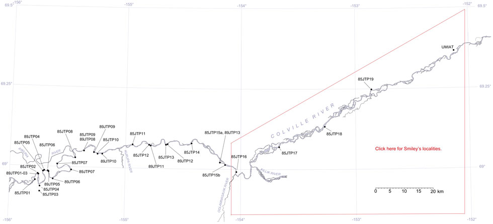
Upper Colville River, Alaska
| Upper Colville Fossil Images Unassigned | Fossil Images 85JTP17 |
|---|
This interactive map of part of the Colville River, Northern Alaska, shows the locations of plant fossil collections made by J.T. Parrish and R.A. Spicer in 1985 and 1989. Click on a number for more details on that site. The red outlined area links to another map showing positions of florules (plant fossil assemblages) collected by C.J. Smiley along both the Colville and Chandler Rivers. |

Locality 85JTP17
Starfish Bluff. This was mapped as the marine Ninuluk Formation, which interfingers with the Cenomanian non-marine Niakogon Tongue (Chapman et al., 1964). Both these units are now referred to the upper part of the Nanushuk Formation of Mull et al. (2003). In fact in the section studied by Parrish and Spicer in 1985 very little of the succession was demonstrably marine. The strongest marine influence appears to be just below 10 m on the lithological column below. Silts immediately underlie an angiosperm leaf-bearing ironstone concretionary layer at the base of the section located about 90 m east of where the river contacted the bluff in 1985. A coal was seen below this ironstone but could not be accessed in 1985 but was reached in 1989. The angiosperms are quite diverse and include Dalembia, Trochodendroides, Ettingshausenia and Pseudoprotophyllum. Conifers include Pityophyllum, the form genus Elatocladus as well as Cephalotaxopsis and Cupressinocladus. The fern Birisia is locally present.
 |
Lithological column of the Starfish Bluff, locality 85JTP17 as logged by J.T. Parrish, July 1985. |
