
Upper Colville River, Alaska
| Upper Colville Fossil Images Unassigned | Fossil Images 85JTP18 |
|---|
This interactive map of part of the Colville River, Northern Alaska, shows the locations of plant fossil collections made by J.T. Parrish and R.A. Spicer in 1985 and 1989. Click on a number for more details on that site. The red outlined area links to another map showing positions of florules (plant fossil assemblages) collected by C.J. Smiley along both the Colville and Chandler Rivers. |
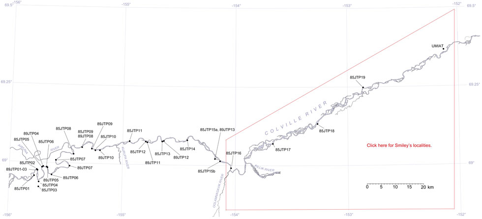
Locality 85JTP18
Ninuluk Bluffs. The base of the section consists of gray shales and represents the marine Ninuluk Formation of Chapman et al. (1964). This is the uppermost part of the Nanushuk Formation of Mull et al. (2003) and is correlative with the non-marine units of the Niakogon Tongue of the Nunushuk Group of Chapman et al. (1964). This is overlain by a fine light olive sandstone which in turn is overlain by a dark gray crumbly clay. Above this is a mudstone/shale succession is followed by a 2 m thick very fine and finely laminated sandstone with small scale crossbedding. This is overlain by a 30 cm thick brown clay. There then follows a succession of clays, carbonaceous shale, a thin (20 cm thick) olive brown sandstone and then a weathered coal associated with nodular and platey ironstones approximately 7-8 cm thick. Above the coal are gray/brown silty weathered shales. The silty shales contain conifer remains and plant hash and water-worn wood is abundant in the sandstones. The succession continues upward with a gray clay underlying a 2-3 cm thick ironstone layer, above which is a 7-8 cm thick mottled gray/brown clay that passes up into 30 cm of olive green poorly indurated fine to medium sand with coal lenses. The coaly partings continue into the base of an overlying well indurated 'salt and pepper' fine sandstone which approximately 1m above has a finely fragmented Inoceramus debris layer suggesting marine deposition. Approximately 2.4 m above this Inoceramus layer the sandstone passes into a 5-6 m thick clay/silt/mudstone succession that passes up into gray/brown mottled clays (pedogenically altered?) in a predominantly fine sandstone succession. Although parts of the succession are covered the presence of a shaley coal approximately 7-8 cm thick above the predominantly sandstone unit suggests a return to non-marine deposition. This coal is the first of several thin coal/carbonaceous shale horizons interspersed by gray mudstones spanning a vertical distance of 5-6 m, but fully non marine conditions were apparently not developed immediately because the basal coal is overlain by a dark gray indurated (calcified?) mudstone that weathers to bright orange at the top of which is a shell horizon. Within this coaly succession occurs a 3-4 cm thick bentonite. The top of this coaly succession is marked by a 45 cm thick fine sandstone.
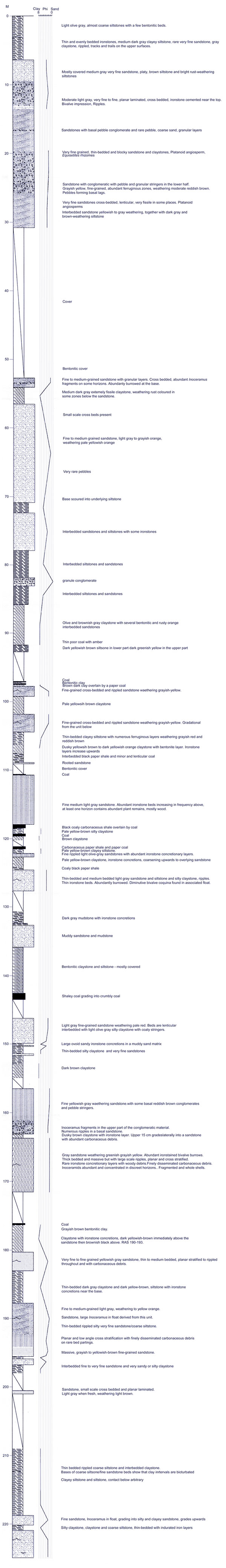 |
Lithologic log of the Ninuluk Bluffs section based on observations by J.T. Parrish in August 1985. |