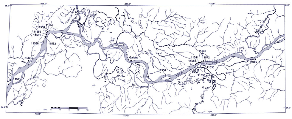
Below are descriptions of the Yukon plant fossil localities. Inaccessible cliffs, vegetation cover, and slumped material prevented detailed stratigraphic work. This has been the case with previous studies in the area and has largely been responsible for the confusion regarding the age of some of the plant beds. Nevertheless, it was possible to locate some of Hollick's original localities and from the map accompanying Hollick's (1930) report, it was possible to assign these recent collections to the Nulato, Melozi, and Kaltag Formations recognized by Hollick and earlier workers. Note that the specimens are not yet illustrated in this catalogue.
11549 Lat. 64°43'30"N Long. 156°07'00"W
Nulato (C-1) Quad. T9S R14E sec. 8 NE1/4 NW1/4
Collected by R. A. Spicer. Fossil Images
Micaceous sandstone and siltstone cliffs. Poorly preserved plant material abundant including large leaves. Matrix friable and sometimes plant debris so concentrated that blocks disintegrate. Massive sandstone with cross-bedding probably represents river channels and contains thin lenses of siltstone yielding plant impressions of varying quality. Some impressions of branches also present.
This locality represents the Melozi Formation as recognized by Martin in Hollick (1930, Plate 87).
11550 Lat. 64°43'30"N Long. 156°07'30"W
Nulato (C-1) Quad. T9S R13E sec. 7 NW1/4 NW1/4
Collected by R. A. Spicer. Fossil Images
Plant fragments in green/gray shales immediately underlying sand and siltstones. Ferns and gymosperms common; angiosperms fragmentary. Large platanoid-like leaves in coarser beds.
This locality represents the Martin's (1926) Melozi Formation as mapped in Hollick (1930, Plate 87) and is approximately equivalent to Hollick's (1930) Lots 3248, 4634 and 4783.
11551 Lat. 64°43'30"N Long. 156°08'00"W
Nulato (C-1) Quad. T9S R13E sec. 7 NW1/4 center
Collected by R. A. Spicer. Fossil Images
Scattered plant remains in gray poorly bedded siltstone blocks at base of cliff.
This locality represents the Melozi Formation (Martin, 1926) as mapped in Hollick (1930, Plate 87) and is approximately equivalent to Hollick's (1930) Lot 3249.
11552 Lat. 64°43'30"N Long. 156°08'20"W
Nulato (C-1) Quad. T9S R13E sec. 7 NW1/4 NE1/4
Collected by R. A. Spicer. Fossil Images
Sandstones, siltstones, and some shales. Plants in finer grained iron-rich micaceous shales. Collections made from float at base of cliff.
This locality represents the Melozi Formation (Martin, 1926) as mapped in Hollick (1930, Plate 87) and is approximately equivalent to Hollick's (1930) Lot 3250.
11553 Lat. 64°43'10"N Long. 156°10'00"W
Nulato (C-1) Quad. T9S R13E sec. 12 NW1/4 SE1/4
Collected by R. A. Spicer. Fossil Images
Plants in shales underlain and overlain by sandstones.
This locality represents the Melozi Formation (Martin, 1926) as mapped in Hollick (1930, Plate 87).
11554 Lat. 64°43'00"N Long. 156°11'00"W
Nulato (C-1) Quad. T9S R13E sec. 12 SW1/4 SW1/4
Collected by R. A. Spicer. Fossil Images
Yellow-gray sandstones and shales. Cliffs not more than 6 m high and slumped. Much fragmented material.
This locality represents the Melozi Formation (Martin, 1926) as mapped in Hollick (1930, Plate 87).
11556 Lat. 64°39'50"N Long. 156°32'00"W
Nulato (C-2) Quad. T9S R12E sec. 31 NW1/4 SE1/4
Collected by R. A. Spicer. Fossil Images
Plant fossils well preserved in iron claystone concretions found as float and in slumped material in low (3 - 5 m) high cliffs.
This locality represents the Kaltag Formation (Martin, 1926) in Hollick (1930, Plate 87) and is approximately equivalent to Hollick's (1930) Lots 3252 and 4635.
11557 Lat. 64°51'45"N Long. 157°54'00"W
Nulato (D-4) Quad. T7S R5E sec. 20 NE1/4 SW1/4
Collected by R. A. Spicer. Fossil Images
Many large 'platanoid' leaves, locally abundant, in the fallen sandstone blocks from 20 m up cliff face.
This locality represents the Kaltag Formation (Martin, 1926) in Hollick (1930, Plate 87) and is approximately equivalent to Hollick's (1930) Lot. 3252.
11558 Lat. 64°31'40"N Long. 157°54'00"W
Nulato (D-4) Quad. T7S R5E sec. 20 NE1/4 SW1/4
Collected by R. A. Spicer. Fossil Images
Abundant large 'platanoid' leaves in fallen sandstone blocks. Some rock unit as 11557.
This locality represents the Kaltag Formation (Martin, 1926) in Hollick (1930, Plate 87) and is approximately equivalent to Hollick's (1930) Lots 2679 and 2964.
11559 Lat. 64°51'10"N Long. 157°55'10"W
Nulato (D-4) Quad. T7S R5E sec. 30 SE1/4 NE1/4
Collected by R. A. Spicer. Fossil Images
Approximately 100 m downstream from cabins on the west bank of the Yukon River. Gray siltstones. Abundant conifer vegetative shoots and a few small angiosperms. Ripple marks.
This locality represents the Kaltag Formation (Martin, 1926) in Hollick (1930, Plate 87).
11561 Lat. 64°51'00"N Long. 157°55'10"W
Nulato (D-4) Quad. T7S R5E sec. 30 NE1/4 SE1/4
Collected by R. A. Spicer. Fossil Images
Siltstones and fine sandstones. Large 'platanoids' in fallen blocks on talus slope.
This locality represents the Kaltag Formation (Martin, 1926) in Hollick (1930, Plate 87) and is approximately equivalent to Hollick's (1930) Lots 3254 and 4786.
11562 Lat. 64°50'40"N Long. 157°55'30"W
Nulato (D-4) Quad. T7S R5E sec. 31 NE1/4 NE1/4
Collected by R. A. Spicer.
Sandstones, shales, and coals approximately 175 m stratigraphically below sandstones of locality 11561. Shales contain cycads and some small, poorly preserved, rare angiosperms.
This locality represents the Kaltag Formation (Martin, 1926) in Hollick (1930, Plate 87).
11566 Lat. 64°48'55"N Long. 157°56'40"W
Nulato (D-4) Quad. T8S R4E sec. 1 SE1/4 SE1/4
Collected by R. A. Spicer.
Fallen block at base of talus slope.
This locality represents the Nulato Formation (Martin, 1926) in Hollick (1930, Plate 87) and is within the lower unit of the interior facies (Kil) of Patton and Bickel (1956).
11571 Lat. 64°37'30"N Long. 158°17'00"W
Nulato (C-5) Quad. T10S R3E sec. 17 SE1/4 NE1/4
Collected by R. A. Spicer. Fossil Images
Poorly preserved plant fossils in shales and sandstones. Shales contain gymnosperms and a few small angiosperms. Large 'platanoids' more commonly found in sandstones. Fragments and impressions of stems and branches in sandstone facies. Sandstones fine upwards into shales before terminating in sharp erosional contact with overlying sandstones.
This locality represents the Kaltag Formation (Martin, 1926) in Hollick (1930, Plate 87) and is approximately equivalent to Hollick's (1930) Lot 3258.
11572 Lat. 64°43'30"N Long. 156°06'50"W
Nulato (C-1) Quad. T9S R14E sec. 8 NW1/4 NE1/4
Collected by R. A. Spicer. Fossil Images
Fallen sandstone blocks on base of talus slope.
This locality represents the Melozi Formation (Martin, 1926) in Hollick (1930, Plate 87) and is approximately equivalent to Hollick's (1930) Lot 2963.
All the above localities are within the upper unit of the interior facies (Kiu) as recognized by Patton and Bickel (1956).
Undocumented Localities
The data for these localities are, at the time of compiling this catalogue, either lost or missing.
Collected by R. A. Spicer. Fossil Images