
Geology
| Introduction | Alaska | Russia | Paleogeography | Energy Resources |
|---|
Energy ResourcesOil and GasNorthern Alaska is known for its abundant oil resources largely as a result of the large finds made in 1968 in the Prudhoe Bay area. However the history of oil exploration extends much further back in time. In 1923 parts of the Arctic Slope were designated as the Navy Petroleum Reserve 4 (NPR-4) and later on the National Petroleum Reserve of Alaska (NPRA); an area subject to extensive oil prospecting between 1944 until 1953. So far Northern Alaska has produced more than 15 billion barrels of oil with reserves of 7 billion barrels and 9.9 hundred billion cubic meters of gas. According to the U.S. Geological Survey nearly twice and much oil and six times as much gas remain to be discovered (Schenk et al., 2012). Overall the Arctic, and especially northern Russia, is incredibly rich in fossil fuel reserves but of all the circum-Arctic depositional basins Northern Alaska is estimated to have the most oil and ranks third in terms of gas potential (Gautier et al., 2009). CoalAs well as oil the Arctic Slope of Alaska contains abundant coal resources of Late Cretaceous and Paleogene age. Estimates vary but a conservative evaluation puts them at 2.75 trillion tonnes, or one third of all US coal reserves combined (Sable and Stricker, 1987). Never having been buried very deeply the coals tend of be of low rank (bituminous and sub-bituminous in th west to brown coals in the east). The coals are also remarkably clean being typically low in sulfur and ash. The thickest seams, up to 5 m in thickness, occur in the Albian to end Cenomanian rocks in the western region, but some seams of similar thickness can be found in the Paleocene sediments along the Sagavanirktok River. In Turonian to Mastrichtian times seams are typically thinner (< 1m). Many of the thinner coals represent peat accumulation in low lying (topogenous) swamps but some of the thicker deposits are likely to represent raised (ombrogenous) mires. Raised mires occur when peat accumulation rises above the groundwater table because it is kept more or less continuously wet by abundant rainfall. Coals also occur, but to a lesser extent, in the Yukon-Koyukuk Basin. A number of small mining operations along the Yukon River supplied local needs and steam powered boats during the 19th and early 20th centuries.
|
 |
||
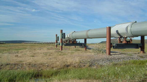
| Trans-Alaska pipeline on the Arctic Slope. | |||
 |
|||
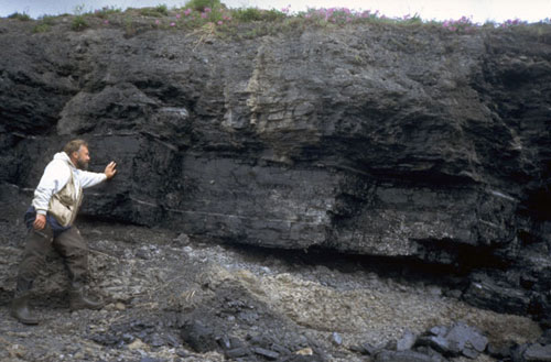
| A coal seam approximately 1.5 m thick exposed along the Kokolik River, western Arctic Slope, Alaska. The coal passes up into a carbonaceous shale. The thin white lines are tonsteins and are often the result of thin volcanic ash falls. | |||
|
|||
 |
 |
||
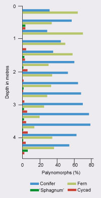
Above: Vertical ash distribution through an Arctic Slope coal (Youtcheff et al., 1987). Right: Vertical distribution of four main palynomorph types through an Arctic Slope coal (Youtcheff et al., 1987). |
|||
Evidence that some coals represent raised mires comes from analyses of ash and palynomorphs throughout the seam thickness. Youtcheff et al. (1987) demonstrated that the ash content tends to rise towards the top of some seams (above left) reflecting recycling of mineral matter by successive cohorts of plants that contributed to the growth of the mire. This is typical of raised mires. The palynomorphs (above right) show a decline in tree taxa (conifers) as the peat (coal) thickness increases concomittant with an increase in herbaceous taxa such as ferns. Again this pattern is typical of raised mires. |
|||