
Grebenka–Orlovka Region
| Grebenka-Orlovka Map | Yelisseev Collection | Yelisseev Section | Grebenka Floral Phase | Fossil Images |
|---|
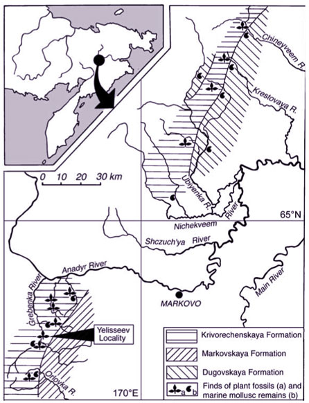
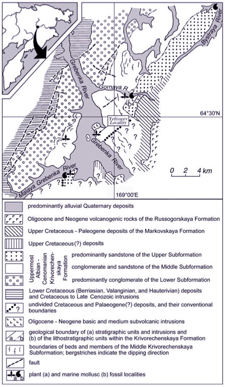
The Grebenka-Orlovka River Basin geology and localitiesThe Yelisseev Locality is the most productive plant fossil locality in this area and is situated approximately 50 km to the south and east of the Okhotsk-Chukotka volcanogenic belt, which was active from late Aptian times through the Late Cretaceous. The succession was deposited in a fore-arc basin, during the accretion of the Kony-Murgal Arc onto the northeastern asian continental margin, i.e., the final closure of the Mongol-Okhotsk Ocean (Nokleberg et al., 1998). The Krivorechenskaya Formation reflects coastal plains and adjacent shallow marine basin depositional environments. The geology of the region is dominated by the influence of the nearby Okhotsk-Chukotka volcanogenic belt (Belyi, 1994), which was the source of much of the clastic material that entombs the fossil flora. The Krivorechenskaya Formation is widely exposed in two areas along the middle reaches of the Anadyr River (see the map on the right). The lithological composition of the Krivorechenskaya Formation and overlying deposits, as well as paleontological remains from them, differ in the two areas and they are therefore here considered separately. 2.1. Geology of the right bank of the Anadyr River On the right bank of the Anadyr River, the plant-bearing deposits of the Krivorechenskaya Formation extend through the basins of the Orlovka, Grebenka, Chukotskaya and Bystraya rivers. The deposits containing the Grebenka Flora overlie Valanginian and Hauterivian rocks with an angular discordance and are divided into two subformations (Devyatilova et al., 1980). The Lower Krivorechenskaya Subformation, 400 - 600 m thick, is largely composed of conglomerates with subordinate layers of coarse-grained sandstones and contain no fossil remains (except for fragmented plant debris). The Upper Krivorechenskaya Subformation is represented by continental conglomerates, sandstones, and siltstones yielding plant remains, and marine beds containing molluscs. It also contains fewer conglomerates than the Lower Subformation. Devyatilova et al. (1980) suggested that on the right bank of the Anadyr River the Upper Subformation is divisible into two members (certain publications treat these members as subformations; Terekhova, 1988). A Lower Member, 400 - 600 m thick, is composed exclusively of continental deposits (mainly conglomerates and sandstones), while an Upper Member, 300 - 350 m thick, differs from the lower by the presence of sandstones and siltstones with a marine fauna. According to Devyatilova (Devyatilova et al., 1980), the Yelisseev Locality belongs to the Lower Member of the Upper Krivorechenskaya Subformation. No marine fossils have been found at the Yelisseev Locality. A locality of the Upper Krivorechenskaya Subformation that contains both plant and marine mollusc remains is situated in the middle reaches of the Gornaya River, 7 km to the northeast from the Yelisseev Locality (see map lower right). Fossil plants similar to those of the Yelisseev Locality have been found here, together with marine molluscs indicating that the locality belongs to the Mantelliceras zones of the standard scale (Pokhialainen, 1994; Gradstein et al., 1994) and to the Hypoturrilites gravesianus ammonite zone and Inoceramus dunveganensis aiensis inoceramid zone of Northeastern Russia, which correspond to beds with I. dunveganensis in Northern Alaska (lower Cenomanian). Determining the age of the Gornaya River Locality is critical to understand better the Yelisseev Locality age, because this is the only site that can be correlated directly with the Yelisseev Locality beds. By combining field observations and information from aerial photographs (V.F. Belyi, pers. commun., 1989), it appears that the Yelisseev Locality is stratigraphically just below the beds of the Gornaya River Locality. Therefore, if this interpretation is correct, the Yelisseev Locality is not younger than the early Cenomanian and is probably earliest Cenomanian or latest Albian and/or earliest Cenomanian in age (Shcepetov et al., 1992; Herman, 1999a, 1999b). In the vicinity of the Yelisseev Locality, two other exposures of the Upper Krivorechenskaya Subformation are known where marine mollusc remains accompany plant fossils. At the Malaya Grebenka River Locality (see maps to the right) fossil molluscs indicate a late Albian to earliest Cenomanian age (ammonite zone Neogastroplites americanus) (Terekhova, 1988; Pokhialainen, 1994). According to Devyatilova et al. (1980), the Malaya Grebenka Locality is also situated stratigraphically above the Yelisseev Locality, but poor exposure renders this conclusion insecure (Sczhepetov et al., 1992; Filippova, 1998). At the Orlovka Mountain locality, near the Orlovka River, inoceramids Pergamentia indicate a late Cenomanian and, possibly, early Turonian age (inoceramid zones P. reduncus and, possibly, Inoceramus labiatus) (V.P. Pokhialainen, pers. commun., 1990). Probable Cenomanian inoceramid remains are also known from the Bystraya River area (Terekhova, 1988). |
|
Interactive map showing the plant and marine localities of the Krivorechenskaya and Dugovskaya Formations. |
Interactive map showing detail of the area surrounding the Yelisseev Locality. |
The uppermost part of the Upper Krivorechenskaya Subformation, 100 - 110 m thick, is represented by conglomerates and coarse-grained sandstones with large-scale cross-bedding. According to Devyatilova et al. (1980), the total thickness of the Upper Krivorechenskaya Subformation is about 700 - 900 m, and the Krivorechenskaya Formation is disconformably overlain by deposits of Maastrichtian (? Senonian) to Eocene age. 2.2. Geology of the left bank of the Anadyr River On the left bank of the Anadyr River (see the upper right shaded area in the upper map) the Krivorechenskaya Formation can be divided into two subformations. The Lower Subformation consists predominantly of conglomerates, whereas the Upper Subformation is represented by conglomerates, sandstones and siltstones (Devyatilova et al., 1980). In the Nichekveem River basin marine molluscs of latest Cenomanian and probably early Turonian age were found in the Upper Krivorechenskaya Subformation (Terekhova, 1988). The total estimated thickness of the Krivorechenskaya Formation in this region is about 1600 m (Devyatilova et al., 1980). The Upper Krivorechenskaya Subformation floral remains in the Krivaya, Vetvistaya and Dugovaya rivers (the Ubiyenka River basin) were studied by Filippova and Abramova (1993) and Filippova (1998) who equated them to those of the Grebenka Flora. Marine deposits of the Dugovskaya Formation, up to 600 m thick, overlie conformably the Upper Krivorechenskaya Subformation (Terekhova, 1988). Mollusc remains indicate a late Turonian age (Terekhova, 1988). However, Terekhova (1988) and Pokhialainen (1994) regard the boundary between continental (Upper Krivorechenskaya Subformation) and marine (Dugovskaya Formation) deposits as diachronous. The Dugovskaya Formation in the Ubiyenka River basin contains Inoceramus concentricus costatus of early to late Turonian age, whereas Inoceramus hobetsensis remains from the Dugovskaya Formation in the Krestovaya and Chineyveem Rivers are of late Turonian and possible Coniacian age. |
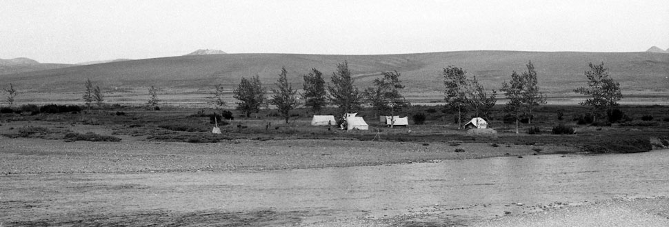 |
| Field camp opposite the Yelisseev locality, Grebenka River, in 1988. |