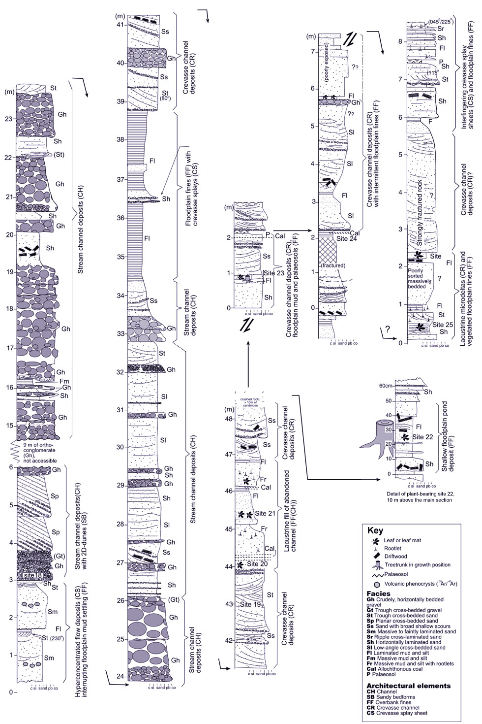
Grebenka Section
| Grebenka-Orlovka Map | Yelisseev Collection | Yelisseev Section | Grebenka Floral Phase | Fossil Images |
|---|
Yelisseev SectionThe section at the Yelisseev locality is approximately 100 meters thick. Each bed is typically traceable laterally for a few meters, at most 50 metres. The following lithofacies observations and architectural elements are the work of Anders Ahlberg (Lund University , Sweden) as reported in Spicer et al. (2002). The lithofacies are coded in accordance with Miall (1978, 1996), and the alluvial architectural elements of Miall (1996) are used for facies subdivision, although there are inevitable limitations imposed by restricted lateral and three dimensional exposure. General sandstone classification is according to Pettijohn et al., (1982), and the nomenclatural schemes of Fischer and Schmincke (1984) and McPhie et al. (1993) are used for pyroclastic sediment classification. The sorting scheme of Folk (1974) is also utilized. |

Conglomeratic Stream DepositsDescription, lithofacies These beds are comprised of tabular, at places slightly trough-shaped, crudely stratified multistorey bodies of clast-supported, matrix-rich conglomerates (lithofacies Gh). Horizontal poorly developed bedding dominate. Maximum clast diameters vary, up to 25 cm. Clast imbrication can be observed, but only in very few beds. Any imbrication is concealed by the pronounced sphaericity of most clasts; an equant shape is typical of volcanic epiclastic debris (Fischer and Schmincke 1984). In rare cases intercalations of very angular pebbles occur. The conglomerates are typically massively bedded, normal graded, and in places amalgamated with low-angle scours into the substrate. Horizontally stratified lenses of coarse-grained sandstone (lithofacies Sm-Sh) occur infrequently within the conglomerates. The same sandstones also form the matrix of the conglomerates. The lenses are 1 - 3 m in width and less than 20 cm in thickness. Lateral exposure did not allow measurements of the widths of the conglomerate units, but they appear to be in order of 100 m in width. Interpretation, architectural element The channel conglomerates are referred to architectural element CH, but it was not possible to break down these conglomerates into downstream or lateral accretion units (i.e., elements DA, LA). The conglomerates were deposited on flat pavements as channel lag deposits of laterally mobile braided channels. Occasional normal grading may be attributed to waning flow due to gradual channel abandonment. Channel bar deposits are probably represented within these conglomerate sheets, but no apparent leeside foresets are apparent in the section to support this assumption. The sand lenses probably filled less active channels of the braidplain. Although sheetformed conglomerates may be produced by repeated catastrophic floods, the Grebenka conglomerate beds show a lack of matrix supported beds, and no observed linear correlation is apparent between maximum clast size and bed thickness; features which have been held typical of such ephemeral events (Nemec and Steel, 1984). Pebbly Stream Channel SandstonesDescription, lithofacies Coarse- to very coarse-grained sandstone in the section make up only very few tabular and trough cross-bedded cosets (lithofacies Sp and Sr). These occur in isolated sandy channels and within channel conglomerates. Moderately sorted, faintly laminated, coarse-grained sandstones with pebble lags along scour-and-fill surfaces occur at several levels (lithofacies Ss), and commonly contain lag surfaces with logs and leaf mats. These sandstones repeatedly grade into floodplain fines and paleosols (see below). At least one sandy channel was rather narrow, approximately 50 - 100 m in width. Channel-fills (Ss units) typically exhibit thicknesses of 1 - 2 m, at most 5 m. Interpretation, architectural element Tabular and trough cross-bedding (lithofacies Sp, St) is interpreted as indicative of downstream foreset migration of 2D and 3D-dunes within channels and crevasse channels (architectural element SB), although bank migration cannot be excluded. Limited paleocurrent data indicate mainly southward river flow. Scour-and-fill-sandstones (lithofacies Ss) represent narrow, <5 m deep, channels which typically were abandoned and subsequently filled with floodplain fines and vegetation (grading into lithofacies Fl, P; see below). Channel size and the intimate interfingering with floodplain fines suggest that these sandstones may represent crevasse channels (architectural element CR). Overbank Hyperconcentrated Flow DepositsDescription, lithofacies These are made up of only two one-meter-thick, sheetformed, massively to crudely bedded, sandstone beds with normal grading. They show flat basal scouring surfaces with pebble lags, followed by massively bedded normal graded coarse-graned sandstones with faint scouring surfaces (lithofacies Sm), trough cross-bedded fine to medium sandstones (St) and final gradation into floodplain fines (lithofacies Fl). The coarse-grained sandstones are very rich in subangular to angular broken crystals and splinters. These beds are interpreted as aqueous hyperconcentrated crevasse splay sheets (CS), being the result of stream channel choking and aggradation by syn-eruptive volcanic ash influx. Levee and Crevasse Sheet SandstoneLithofacies, description At places within overbank fines, thin, horizontally stratified (Sh) to trough cross-bedded (St) normal graded beds of pebbly sandstone occur, occasionally with tree trunks and roots in growth position. These deposits are, in their proximal parts, commonly stacked and slightly amalgamated into the substrate. Occasionally they fine and thin away distally, interfingering conformably with floodplain fines. Interpretation, architectural elements Proximal overbank floods appear to have passed between mature trees growing on the river bank or levee (architectural element LV). These trees probably slowed down the overbank flow profoundly, and induced sand deposition. They also hindered erosion of the levee. Overbank flow which continued to lower, more distal, parts of the floodplain lost even more energy and consequently laid down crevasse splay sand sheets (architectural element CS) in otherwise undisturbed overbank areas. Floodplain Pond and Microdelta Deposits
|
