
Kokolik River
| Introduction | Northern Alaska Map | Kokolik Unassigned Fossils | Fossil Images |
|---|
Interactive map of western northern Alaska showing the positions of the plant fossil localities along the Kokolik River. Some specimens are representative of taxa occuring throughout the Kokolik sections and are unassigned. Where specimens are assigned to specific localities the 'Fossil Images' link becomes active. Locality 98RAS09:69.461141°N -161.382558°WNo material collected or photographed.
|
|

Locality Description:
This locality is near the axis of Carbon Anticline. It is a long well exposed section rich in coal and carbonaceous shales. Overall the section represents a topogenous interfluve mire environment periodically inundated by fluvially-derived siliciclastics. Minor channel sands and crevasse splay sediments are evident.
The flaggy fine sands of beds 3 and 4 are rich in Ginkgo, Ginkgo fragments and Desmiophyllum or ?Baiera. Nilssonia leaves are present in ironstone nodules that occur in gray mudstones that occur between the sands. Desmiophyllum, however, is the most numerous taxon along with Pityophyllum. Log and branchwood is abundant. Logs up to 40 cm in diameter was seen as float but was poorly preserved.
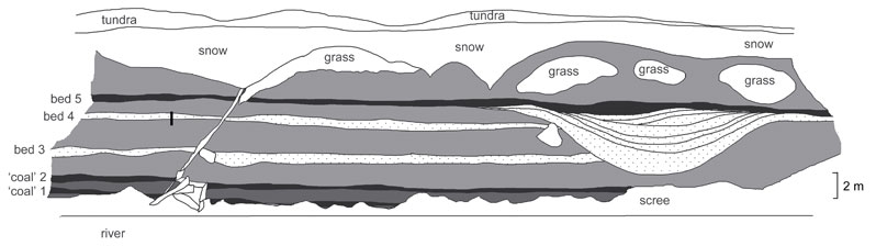
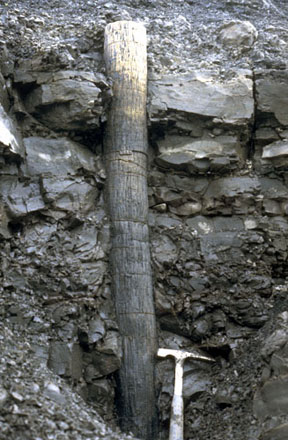
Sketch of the 98RAS09 section. The upright tree stump arrowed below, and illustrated in the field photographsat the bottom of the page, is shown as a vertical black line intersecting with bed 4 on the left of the sketch.
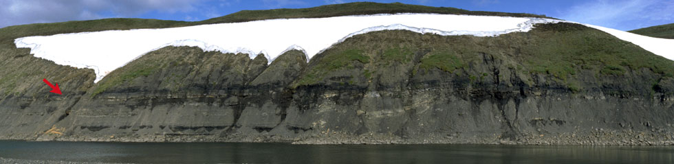
Composite panoramic photo of the 98RAS09 locality. The red arrow shows the position of the in situ tree shown in the images below.
 |
 |
| Detail of the upright tree stump arrowed above. | The cliff section showing the tree stump in context. |