
Upper Colville River, Alaska
| Map of Northern Alaska | Upper Colville Fossil Images Unassigned | 89JTP01 Images | 89JTP02 Images | 89JTP03 Images |
|---|
This interactive map of part of the Colville River, Northern Alaska, shows the locations of plant fossil collections made by J.T. Parrish and R.A. Spicer in 1985 and 1989. Click on a number for more details on that site. The red outlined area links to another map showing positions of florules (plant fossil assemblages) collected by C.J. Smiley along both the Colville and Chandler Rivers. |
Locality 89JTP01, 89JTP02 and 89JTP03
Description:
These localities were previously sampled in 1985 where the locality is designated 85JTP02 and is mapped as belonging to KcKt (lower part of the Killik Tongue of the Chandler Formation and Tuktu Formation undifferentiated, Chapman et al., 1964). Mull et al. (2003) reassigned this unit to the middle part of the Nanushuk Formation.
In 1989 Parrish divided the section into 5 units. Unit 1 is at the base of the section where a gray silty mudstone rooted by Equisetites (with nodules) is eroded into by a cross bedded yellow/orange lenticular sandstone. The base of the sandstone (designated Unit 2a) contains abundant water-worn wood fragments ranging from branches to small comminuted plant hash, together with gray mud clasts. The wood fragments are poorly sorted and poorly orientated. Unit 2b is the main part of the crossbedded sandstone also contains abundant woody debris impressions and compressions throughout. The largest log seen was 31 cm in diameter. This sandstone fines upwards becoming grayer and siltier. In this upper part of Unit 2b washed in plant debris is more abundant and includes Equisetites and Pityophyllum. Unit 2c is a yellow/gray indurated sandstone overlying Unit 2b and contains taxodiaceous conifer fragments.
Unit 3 is a yellow/gray partly indurated, banded, rooted siltstone with rare plant fragments and ironstone nodules. Bedding not well developed and in the middle of the unit branches and roots up to 1.5 cm in diameter lie parrallel to what bedding exists.The upper part, approximately 1 m below the main coal bed, the sediment is a fine yellow/light olive/gray sandstone with Pityophyllum conifer leaves, together with uinidentifiable roots and branches. Above this sand is a gray abundantly rooted, poorly bedded siltstone passing up into a darker clay-rich siltstone at the base of the coal. This 'seat earth' contains rare Pityophyllum leaves and Equisetites rhizomes.
Unit 4 is the coal, the base of which is rich in impression/compression remains of Pityophyllum nordenskioldii but apparently non-woody in that large branches are absent. This suggests that Pityophyllum nordenskioldii may not have been a tree but a small bush, or even herbaceous. Otherwise the caol is devoid of identifiable plant material.
Unit 5 is a yellow/olive gray siltstone with poorly developed bedding overlying the coal. Equisetites rhizomes occur throughout, but only sparsely except in a paper coal approximately 60 cm above the main coal bed.
Float along the beach indicated that Pityophyllum nordensklioldii occurs abundantly in fine-grained ironstones sheets and nodules, and in fine grained lags within crevasse splay sands.
| Sketch of the 85JTP02 section (slightly shortened horizontally). The red rectangle indicates the part of the section shown in the photograph below. The red line shows the approximate position of the representative sedimentary log below. | 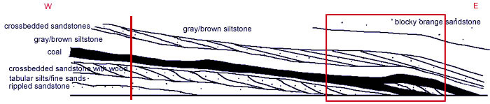 |
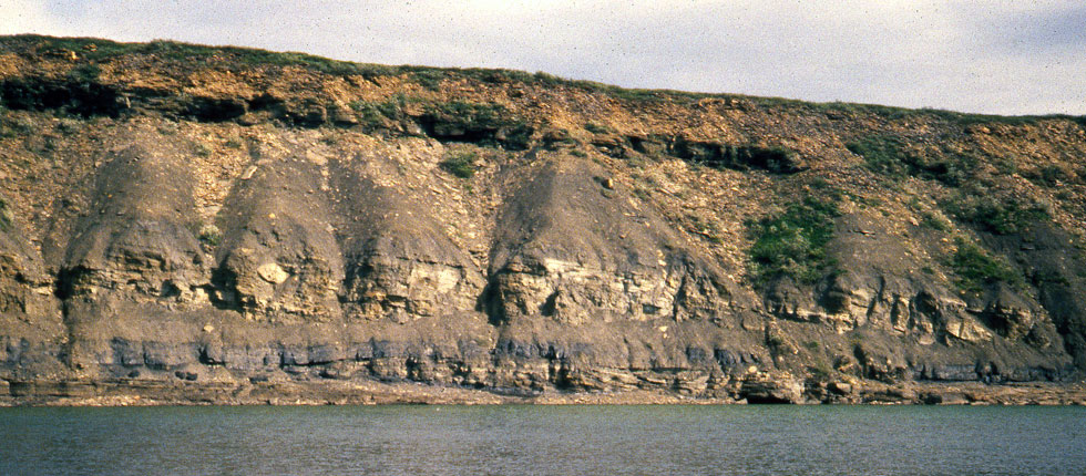 |
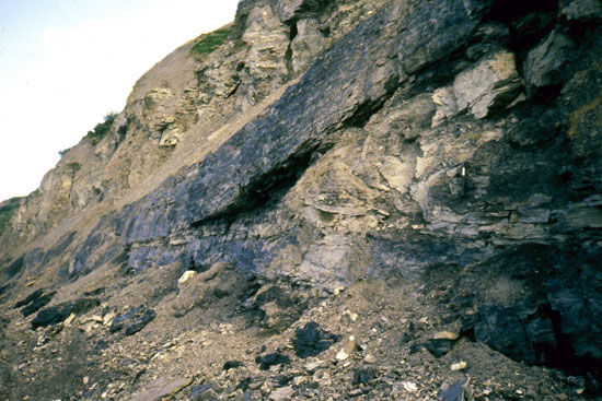
| Field photograph of the section at 85JTP02. The approximate height of the section is 20 m. |
 |
 |
|
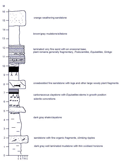
Above: detail of the split in the coal seam in the 85JTP02 and 89JTP03 sections looking west. Left: representative sedimentary log of the 85JTP02 section. |
Approximately 300 m downstream of 89JTP01 the lateral equivalent of Unit 2 exhibits climbing ripples and the rippled surface is abundantly marked by worm tracks and some burrows (see below) and periodically were probably aerially exposed. This is also suggested by some drainage ripples aligned at right angles to, and within, the troughs of the major ripples. Pityophyllum leaves also occur along with large quantities of comminuted plant hash and some Sphenobaiera-like leaf fragments.
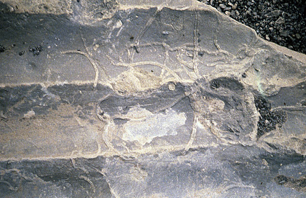 |
Field photograph of invertebrate trails on a rippled surface.
|
Approximately 50 m upstream of 89JTP01 a large fallen block exposed a bedding surface with numerous small liverwort-like plants. These appear to have been growing on a clay-draped surface on a fine thick sandstone equivalent to Unit 3 of 89JTP01.
Description:
Approximately 0.5 km downstream of 89JTP01. The section is exposed below the sandstone that is equivalent to Unit 2 of 89JTP01 and begins with a dusky yellow/brown laminated claystone that is slightly silty in places grading upwards into a dark gray silty thin bedded current laminated claystone with occasional ironstone nodules. This in turn passes into a rippled fine sandstone that is rooted.
The next unit (Unit 2 at this locality) is a poorly bedded very dark yellowish brown slightly silty claystone with increasing silt content at higher levels as the unit becomes lighter. Equisetites rhizomes are abundant in the lower part of this unit. At the top of the unit the silt component declines.
Unit 3 is a very fine poorly bedded sandstone without visible sedimentary structures except for a wavey base and some suggestion of small scale cross stratification. The upper part is bioturbated by rooting with plant debris composed of conifer leaves, seeds and Equisetites rhizomes fragments not in growth position. This is equivalent to Unit 2 at 89JTP01.
Unit 4 begins with a gradational contact with the underlying Unit 3. It is a massive, very poorly bedded, hackly muddy siltstone that is dark yellowish brown with common ocurring plant debris. Some beds are sandy with very fine sandstone horizons. The middle third of this unit was, in 1989, covered. The upper part is olive/black, rooted (Equisetites) and a silty claystone that becomes more coaly towards the top. Pityophyllum, Equisetites and possible Sphenobaiera occur near the top of this unit.
Unit 5 is a coal equivalent to Unit 4 of 89JTP01.
Unit 6 was not accessive to examine closely in 1989 but is estimated to be a 12 m thick gray brown siltstone with some foreset beds.
Description:
This section is that at the coal split shown above.
Unit 1 Medium dark gray to yellowish fine sandstone with abundant plant material. Cleaner parts of the sandstone show small scale ripples. Equisetites rhizomes are abundant, Pityophyllum leaves are rare as are possible cupressaceous conifer shoots.
Unit 2 Massive nodular-weathering dark yellowish brown clayey siltstone with abundant plant remains in the lower half. Equisetites rhizome systems abundant along with cones and Cephalotaxopsis leafy shoots. Contact with Unit 1 is gradational. There is a small (20 cm thick) brownish-black siltstone with abundant carbonaceous material. The upper part of the unit contains ironstone nodules. The contact with the coal is gradational in some places but quite sharp in others.
Unit 3 Coal beginning with a paper shale. Equisetites fragments present together with some Pityophyllum. Ginkgo, other ginkgophytes and ferns are absent. The top of the coal is irregular with rip ups in the lower part of the overlying unit and abundant caoly streaks that are probably compressed logs.
Unit 4 Current-laminated very fine sandstone to siltstone with small scale hummock and swale type sedimentary structures. This unit is the sediment forming the split in the coal. Coaly stringers are probably logs and ripups from the underlying coal. Moving east from the west end of the split the base of the split is fine to very fine sandstone with current laminations and ripples. Above this the unit is poorly bedded to massive, hackly-weathering muddy rooted siltstone. Ironstone nodules are present. There is a discontinuous unit of lenticular massive very fine to fine rooted sandstone within the siltstone. The sandstone has a very irregular base, almost ball and pillow. The lower current laminated sandstone has an in situ tree base sticking up through it, although logs are abundant. The split is at least 2.5 thick where the section was examined. The bases of the foreset units in the split converge onto the lower part of the coal. Approximately 20 m downstream from the tree base the basal sandstone is medium grained with current aligned (roughly N-S) impressions of logs. Identifiable plant fragments include isolated Pityophyllum, large-leaved Ginkgo, possible cupressaceous leafy shoots and inwashed Equisetites rhizome fragments. The upper surface of the sediment forming the split has ironstones with impressions of logs up to 13 cm in diameter, Equisetites rhizome fragments with nodules, Cephalotaxopsis shoots, Pityophyllum staratchinii and possible Sphenobaiera. Intervening surfaces have rare log impressions. The upper surface is irregular and is a muddy fine sandstone grading up into a 20 cm thick heavily rooted siltstone and claystone.
Unit 5 is the upper part of the split coal seam.
Unit 6 is a hackly-weathering massive siltstone above the upper part of the coal and Unit 7 is a large scale (foreset) crossbedded unit above that. The upper part of Unit 6 is a dusky yellowish brown coaly and clayey siltstone that grades up into Unit 7. Unit 6 contains abundant Pityophyllum staratchinii, possible Ginkgo fragments and vertically compressed (into a zig-zag shape) stems.
Unit 7 is a silty claystone with ironstone nodules and plant debris interbedded with current-laminated rooted very fine sandstone. Float derived from this unit contains, abundant Equisetites rhizomes (some with nodules), Pityophyllum, abundant wood fragments, conifer cones, abundant Cephalotaxopsis shoots, Nilssonia, Sphenobaiera and Ginkgo leaves.
Capping this sandstone is a poorly bedded sandstone, which is thin-bedded at the base with current laminations and low angle cross stratification. Log impressions are common in the upper part of this unit.