Geology - Arctic Slope, Alaska
| Introduction | Alaska | Russia | Paleogeography | Energy Resources |
|---|
| NASR Geology | NASR Stratigraphy | NASR 3D Model | Yukon-Koyukuk | Chignik | Nelson/Nunivak Islands |
|---|
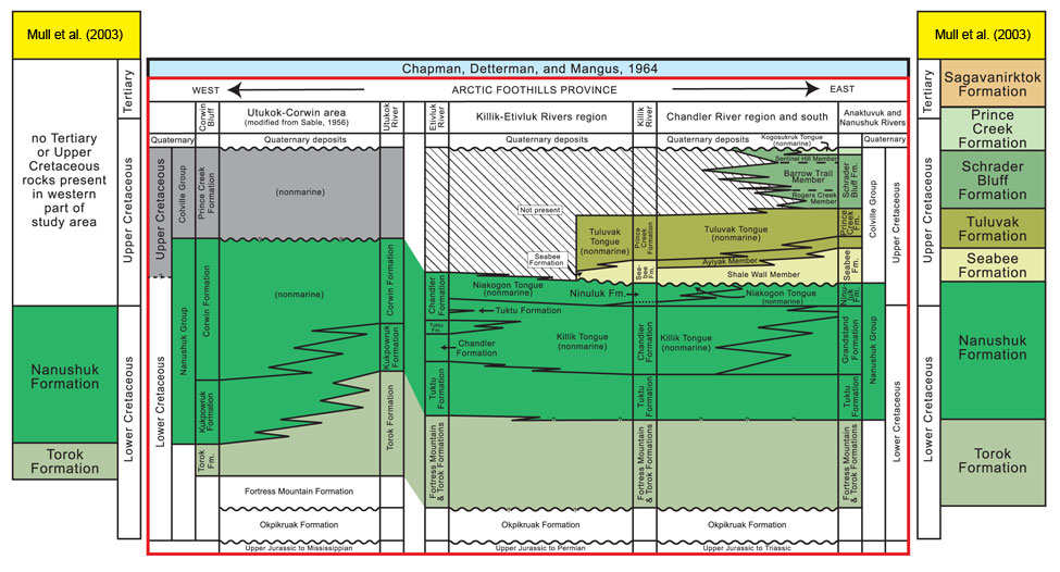
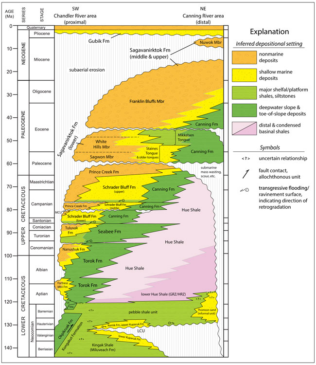
| Mull et al., (2003) rationalised the stratigraphic nomenclature for the Cretaceous and Tertiary rocks of northern Alaska and their scheme is summarised in the graphic above. Many of the names of Chapman et al. (1964) were abandoned by Mull et al. (2003) but we have retained some of these terms as names of floras that are specific to particular time intervals. It is possible to subdivide formations based on their plant fossil content. A chronostratigraphic chart for the Chandler to Channing River area based on Gillis et al. (2014) is given at the bottom of this page. |
|
The Aptian to Cenomanian Torok Formation is an important region-wide thick mappable unit of soft fine-grained marine sediments originally named by Gryc et al. (1951) and revised by Patton (1956). Mull et al. (2003) retained Patton's (1956) concept of the unit and described the lithology as "..dark-gray to black silty shale, mudstone, and clay shale with interbedded thin-bedded siltstone and lesser amounts of greenish-gray, thin-bedded siltstone and fine-grained sandstone. Fine- to medium-grained sandstone also is common in the lower part of the formation. Channelized, thin-bedded fine- grained sandstone and debris-flow deposits are locally present in the lower part of the formation in the southern part of the fold belt" (p. 9). Dating is based on limited outcrop occurrences of early and middle Albian ammonite and pelecypods (Detterman et al., 1963; Elder et al., 1989; Cole et al., 1997) and seismic data that shows the upper part of the Torok is equivalent to the uppermost part of the Nanushuk Formation (Cenomanian) (Houseknecht and Schenk, 2001). |
| To Page Top |
|
The Nanushuk Formation is rich in plant fossils and has undergone a series of terminological revisions summarised by Mull et al. (2003) as follows: "Gryc and others (1951) applied the name "Nanushuk Group" to a thick series of resistant sandstone and conglomerate beds interbedded with shales, siltstones, and coals and exposed along the Nanushuk River in the east- central Colville basin. The group contained the Chandler and Umiat Formations; the Umiat Formation later was abandoned by Gryc (1956). Detterman (1956a) revised the group to include several intertonguing dominantly marine and nonmarine formations and tongues, in ascending order: the Tuktu Formation (dominantly marine), the Grandstand Formation (transitional marine and nonmarine), the Chandler Formation, and the Ninuluk Formation. The lower part of the Chandler Formation, which was considered to be dominantly nonmarine, was termed the Killik Tongue. The Killik Tongue, as defined by Detterman (1956a), was overlain by interfingering marine beds of the Ninuluk Formation and nonmarine beds of the Niakogon Tongue of the Chandler Formation, which together formed the top of the Nanushuk Group. In the western part of the Colville basin, Sable (1956) revised the Nanushuk Group to consist of two formations: dominantly marine sandstones of the Kukpowruk Formation at the base interfinger upward with dominantly non- marine sandstone, conglomerate, and interbedded coal of the Corwin Formation. Genetically and lithologically, the Kukpowruk Formation resembles the Tuktu Formation of the central Colville basin, and the Corwin Formation resembles the Chandler Formation." (p. 12). After extensive fieldwork Mull et al. (2003) concluded that a number of the lithostratigraphic units were not lithologically distinctive, were difficult to distinguish and trace laterally in the field and did not confirm to the North American Stratigraphic Code (North American Commission on Stratigraphic Nomenclature, 1983). They therefore reduced the rank of the Nanushuk to create the Nanushuk Formation with informal lower (marine) and upper (non-marine) subdivisions. The Kukpowruk, Tuktu, Grandstand, Corwin, Chandler, and Ninuluk Formations were abandoned by Mull et al. (2003) along with the Killik and Niakogon Tongues of the Chandler Formation. Here, however, we retain some of those names for specific floras. The Nanushuk Formation contains locally abundant marine fossils (pelecypods, ammonites, gastropods) indicative of a middle Albian to Cenomanian age (Detterman et al., 1963; Brosgé and Whittington, 1966). |
| To Page Top |
|
The Seabee Formation as revised by Mull et al. (2003) consists only of the rocks formally assigned to the Shale Wall member of the old Seabee Formation, a subdivision of the now abandoned Colville Group. The contact of the Seabee Formation with the underlying Nanushuk Formation is both abrupt and conformable resulting from a major marine transgressive flooding surface. The upper part of the Seabee Formation interfingers with thin-bedded sandstones and siltstones of the Tuluvak Formation of Mull et al. (2003). The poorly indurated bentonite-rich sediments of the Seabee Formation are predominantly mudstones, silty mudstones and dark gray to black fissile, organic rich paper shales. Some silicified tuff beds also occur. Although traditionally regarded as no older than Turonian (Lanphere and Tailleur, 1983) based on marine fossils, isotopic dating of bentonites indicates an age range of 93.6 to 91.5 Ma, and thus the oldest Seabee Formation rocks are latest Cenomanian (Gradstein et al., 2004). |
| To Page Top |
|
Conspicuous sandstones and conglomerates referred to as the Tuluvak Tongue of the Prince Creek Formation are easily mapped and so were elevated to formation status by Mull et al. (2003). The Tuluvak Formation now includes coarsening upward interbedded shales, siltstones and fine-grained sandstones formerly assigned to the now abandoned Aiyak Member of the underlying Seabee Formation. The Tuluvak Formation is coarsest in its middle part and consists of abundant cobble to boulder conglomerates but the clast size and thickness decreases markedly in an eastward direction. This is interpreted to be the result of an eastward to northeastward progression and a transition from from a braided river to shallow marginal marine environment. North of the Colville River, and particularly in the Ikpikpuk River quadrangle, interbedded coals and carbonaceaous shales occur. See Localities 11606 and 11493 on the Northern Alaska map for more details of the plant-bearing facies of the Tuluvak Formation. The Tuluvak Formation of Mull et al. (2003) is late Turonian to Coniacian in age based on marine megafossils in the lower units (previously the Aiyak Member) and the Santonian age of the overlying Schrader Bluff Formation (Brosgé and Whittington, 1966). |
| To Page Top |
|
Gryc et al. (1951) named a dominantly marine sandstone and shale unit overlying the Tuluvak Formation as the Schrader Bluff Formation. Originally the Schrader Bluff Formation was divided into, in ascending order, the Rogers Creek, Barrow Trail and Sentinel Hill Members but these were abandoned by Mull et al. (2003) and replaced by lower, middle and upper parts of the Schrader Bluff Formation where appropriate. The lower parts of the Schrader Bluff Formation are characterised by relatively pure bentonite interbedded with bentonitic shale, tuffaceous mudstone and bentonitic fine-grained fossiliferous sandstone. The upper part of the formation is gradational upward into the sandstones, mudstones and coals of the overlying Prince Creek Formation and represents a shallow marine environment. In its revised form the Schrader Bluff Formation is Santonian to Maastrichtian based on marine mega- and microfossils (Detterman et al., 1963; Brosgé and Whittington, 1966; Mull et al. 2003). |
| To Page Top |
|
Originally the Prince Creek Formation, named by Gryc et al. (1951), was subdivided into two predominantly non-marine tongues, The Tuluvak Tongue at the base and the Kogosukruk Tongue at the top. Mull et al. (2003) abandoned the term 'Kogosukruk Tongue' but here we use the name 'Kogosukruk' for the fossil flora found in rocks previously assigned that name. Brown-weathering coal-bearing rocks previously assigned to the lower part of the Sagwon Member of the Sagavanirktok Formation are now included in the Prince Creek Formation while the Tuluvak Tongue is elevated to formation rank. The Prince Creek Formation typically consists of light- colored, nonmarine sandstones interbedded with carbonaceous mudstone, coal, and bentonite. Throughout much of the formation the sandstones are very fine to fine grained and variably tuffaceous and exhibit low angle bedding interpreted to represent accretionary beds deposited in a meandering fluvial regime. These low energy fluvial sediments are interbedded with marginal marine and shallow marine deposits. The marine influence generally increases upsection and the top of the section measured by Phillips (1988, 1990) is capped by a fully marine fossiliferous 14 m thick sandstone. The revised Prince Creek Formation of Mull et al. (2003) is regarded as being Campanian to middle Paleocene (Selandian, ~60 Ma) based on palynomorphs and foraminifera (Micropaleo Consultants, 1994; Frederiksen and others, 1996; Frederiksen and McIntyre, 2000; Daly et al. 2011a). |
| To Page Top |
|
The Sagavanirktok Formation (Gryc et al., 1951; Detterman et al., 1975) consists of poorly consolidated siltstone, sandstone, conglomerate and lignites of Tertiary age and was revised by Mull et al. (2003) to consist of a basal Sagwon Member overlain by the White Hills Member and then the Franklin Bluffs Member. Of particular relevance here is the Sagwon Member. This is characterised by a conspicuous white-weathering sandstone and conglomerate unit that abruptly overlies the brownish-gray, silty and sandy mudstones and claystones with coals and minor conglomeratic sandstone beds make up most of the Sagwon Bluffs and that belong to the revised Prince Creek Formation. The base of the Sagwon Member is regarded as a sequence boundary. The upper parts of the Sagwon member are overall finer grained and typically consist of poorly consolidated claystones, siltstones, sandstones and coals. The sudden increase in grain size is attributed to rejuvenation of uplift in the Brooks Range and downward flexing of the foreland basin providing addition accomodation space (Gillis et al., 2014). The age of the Sagwon Member is late Paleocene based on palynomorphs from the upper coal-bearing part of the member in the eastern White Hills (Frederiksen at al., 1996). |


