
Geology - Alaska and the Arctic Slope, (NASR)
| Introduction | Alaska | Russia | Paleogeography | Energy Resources |
|---|
| NASR Geology | NASR Stratigraphy | NASR 3D Model | Yukon-Koyukuk | Chignik | Nelson/Nunivak Islands |
|---|
Most of the Alaskan fossils featured in this catalogue come from the Arctic Slope of Alaska, which is a large area north of the Brooks Range where Cretaceous and Paleogene rocks are exposed along river incisions and yield abundant plant fossils defining the paleofloristic area known as the North Alaskan Subregion (NASR).
 |
|
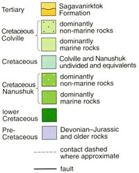 |
This generalised geological map of the Arctic Slope of Alaska shows the rocks immediately underlying the Quaternary cover and divides Cretaceous rocks into the Nanushuk and Colville Groups following Chapman at al. (1964). For the relationship with the more recent revision of Mull at al. (2003) see the regional stratigraphy. |
In Alaska, and specifically the Northern Alaska Sub-Region (NASR), Cretaceous–Paleocene plant-bearing deposits are widespread to the north of the Brooks Range within the areas occupied by the Colville basin during the Cretaceous, and by the Camden basin in the Paleogene (Sable and Stricker, 1987; Grantz et al., 1990). In terms of landscapes and composition of deposited sediments, the NASR is similar to those of the Anadyr–Koryak subregion, although unlike the AKSR older lower–middle Albian deposits are known in Northern Alaska. During the Late Cretaceous and Paleogene the Arctic sea basin adjoined the NASR to the the north, and the subregion was bounded by a partly uplifted Brooks Range from the south. The Cretaceous sedimentary rocks of Northern Alaska are composed of materials mostly eroded from the Brooks Range, although there may have been a contribution from Chukotka (Kelley et al., 1999; Moore et al., 2015) where main events of deformation and uplift commenced in the terminal Jurassic – initial Cretaceous time and lasted, episodically, through into the Tertiary. As is evident from the map, older Late Cretaceous sediments are in the west and younger deposits in the east. This shows that infilling of the Colville foredeep to the north of the Brooks Range took place predominantly in a west to northeast direction throughout the Late Cretaceous (Decker, 2007). Sedimentation ceased earlier in the west than in the east and in eastern parts of the North Slope numerous intercalations of marine and non-marine units persist into the Late Cretaceous. This pattern of deposition is evident in the phytostratigraphy of northern Alaska and the 'L' shaped distribution of the non-marine middle Cretaceous (Nanushuk) rocks in the map above. Apatite fission-track analysis of Brooks Range and Colville Basin rocks has documented periods of cooling, attributable to episodes of uplift and erosion at approximately 100 Ma (Albian), 60 Ma (Late Paleocene), 43 Ma (Eocene), 34 and 25 Ma (Early and Late Oligocene) (Mull, 1979, 1982, 1985; Grantz et al., 1990; Murphy et al., 1992; Hanks et al., 1992; O’Sullivan, 1992, 1996, 1999; O’Sullivan et al., 1998a, b). Each of these episodes is estimated to have taken place over a period of less than 5 My, and involved at least 2 km of uplift and subsequent erosion (O’Sullivan, 1992). Exactly how high the Brooks Range was in the Cretaceous is unknown. Studies of the metamorphic core demonstrate very rapid exhumation (via shortening and extension), which almost certainly created substantial relief. By comparison with other fold thrust belts around the world exhibiting a similar scale of shortening and thickening this would suggest a globally significant mountain range. This mountain belt must have been large enough to flex the entire lithosphere and generate the observed tectonic subsidence. Also, the volume of Aptian-Cenomanian sediment suggests that it unroofed a very large upland region (Marwan Wartes, personal communication, 2016). However, coarse sediment is rare in the Late Cretaceous terrigenous deposits: fluvial channel depsosits with sediment coarser than medium sand are uncommon, as are conglomerates. Chemical rather than mechanical weathering processes appear to have dominated during the extensive Late Cretaceous erosion of the mountain belt, but this is not surprising if the lower elevations of the mountain range were exposed to year round temperatures that barely dipped below freezing (Herman and Spicer, 2010; 2016). By way of contrast, today’s rivers draining northwards from the Brooks Range are full of cobbles, pebbles and coarse sand, with mechanical weathering, amplified by the freeze-thaw cycle, predominating. During the globally colder Maastrichtian seasonal flooding of the North Slope floodplains is evident (Flaig et al., 2011; 2013; 2014) possibly resulting from summer snowmelt at higher elevations. Plant-bearing deposits of the NASR are known in the Nanushuk (Albian–Cenomanian) and Colville (Turonian–lower Paleocene) Groups within the asymmetric Northern Alaska foreland with its axis at approximately 70 °N that plunges gently in an eastern direction. Within the foreland limbs, the rocks under consideration here are deformed into comparatively simple, commonly gentle, folds. The Albian – lower Paleogene sediments of the NASR represent classical postorogenic deposits of the molassic type characterizing alluvial plain and deltaic sedimentation settings. These are shallow-water marine sediments of prodelta and intercalated continental (lagoonal, coastal, estuarine, deltaic, and alluvial) deposits (Mull, 1979; Sable and Stricker, 1987). Periods in evolution of the NASR flora, which are inferred from taxonomic composition and stratigraphic position of taphofloras in the subregion, are used in this work to underpin the Albian – Paleocene phytostratigraphic scheme of the subregion that is different from those suggested earlier by Smiley (1966, 1967, 1969a, 1969b). In Herman (2011a), the Albian – early Paleogene floral evolution in the NASR is divisible into the Kukpowruk, Niakogon, Kaolak, Tuluvak, Early Kogosukruk, Late Kogosukruk, Early Sagwon and Late Sagwon phases, eight in total. Their duration (Harland et al., 1990) ranges from 2 – 3 (Tuluvak and Early Sagwon phases) to 9 – 10 m.y. (Kukpowruk, Early Kogosukruk and Late Kogosukruk phases). Floras of the phases differ from each other in (1) the proportions of different plant groups (ferns, cycadophytes, ginkgophytes, leptostrobaleans, conifers, angiosperms), (2) the taxonomic composition of the groups at the generic and species levels, (3) the dominant plant taxa, and (4) the relative abundance of advanced and relictual plants. In general, the Albian – early Paleocene flora of the NASR evolved gradually, in an autochthonous manner under control of physiographic factors and climatic changes. Floras of the Kukpowruk and Niakogon phases of floral evolution are traceable in each of the Utukok-Corwin, Kuk-Kaolak, and Umiat-Chandler areas of the NASR, and the Kaolak phase in just the Kuk-Kaolak and Umiat-Chandler areas. Because of this, it was possible to distinguish the Kukpowruk (?lower to middle – ?upper Albian), Niakogon (upper Albian – Cenomanian), and Kaolak (Turonian) phytostratigraphic horizons as subdivisions of subregional extent within the NASR. Fossil floras of five other subdivisions (Tuluvak, Early and Late Kogosukruk, Early and Late Sagwon phases) are known each in one particular area of the subregion, and so are suitable only for distinguishing the individual plant-bearing beds within the areas in which they occur. At present, geographic ranges of corresponding floras (regional or local) and their correlation potentials are unclear.
|